
Convective instability occurs when dry mid-level air advects over very warm and moist air in the lower troposphere. Convective instability is released when dynamic lifting from the surface to the mid-levels produces a moist adiabatic lapse rate of air lifted from the lower troposphere and a dry adiabatic lapse rate from air lifted in the middle troposphere. Over time, this increases the lapse rate in the troposphere and can cause a troposphere with little or no Surface Based CAPE to change to one with large SBCAPE (relative to a parcel of air lifted from the surface). Dry air cools more quickly when lifted compared to moist saturated air. Convective instability exists when the mid-levels of the troposphere are fairly dry and high dewpoints (and near saturated conditions) exist in the PBL. Water vapor imagery detects moisture in the 600 to 300 millibar range in the troposphere. A dark color on water vapor imagery implies a lack of moisture in the middle and upper levels of the troposphere. The surface, 850 mb, and 700 mb charts can be used to assess the low level moisture profile. The best way to analyze convective instability is by the use of a Skew-T diagram. A hydrolapse (rapid decrease of dewpoint with height) will exist at the boundary between the near saturated lower troposphere and dry mid-levels. Below is a sounding displaying convective instability. The morning sounding shows no significant CAPE. However, a forecaster would expect daytime heating to increase SBCAPE. If lift also occurs in this sounding environment (from dynamic lifting mechanisms such as WAA, low level convergence, upper level divergence (jet streak, PDVA)) then CAPE will increase even further because the lifting will cool the mid-levels at a rate greater than the low levels. 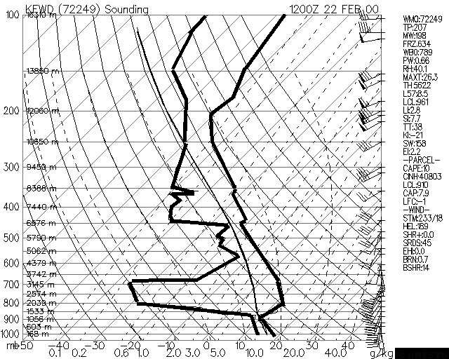
|