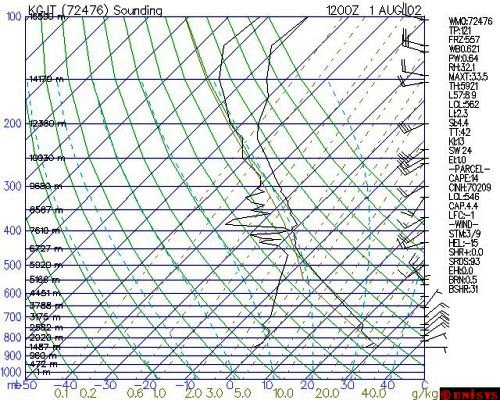
1. What is LCL? The LCL (Lifted Condensation Level) is the pressure level a parcel of air reaches saturation by lifting the parcel from a particular pressure level. A rising parcel of air cools, thus the relative humidity increases inside a rising unsaturated parcel. Once the RH first reaches 100% in the parcel, the LCL occurs there. 2. How is LCL determined? First note the temperature and dewpoint that is 50 mb above the surface pressure. Draw a line parallel to the dry adiabatic lapse rate starting from the temperature that is 50 mb above the surface. Draw a line parallel to the mixing ratio lines starting from the dewpoint that is 50 mb above the surface. The intersection of these two lines is the LCL. The sounding at the bottom shows a LCL of 546 mb. It is very high since the PBL is very dry. *note: Different computer algorithms will often have different starting conditions for the parcel. Some will use the surface temperature and dewpoint. Some will use the temperature and dewpoint that is 50 mb above surface. Some will use the average temperature and dewpoint is the PBL. Parcels of air that are used to locate the LCL originate from the PBL. Mixing of air is frequent in the PBL-- thus the use of the temperature and dewpoint toward the center of the PBL (50 mb above surface) is a good starting point. 3. Operational significance of LCL: Cloud bases: It determines how far air needs to be lifted to produce clouds. Tornado: In a supercell thunderstorm situation, a low LCL (closer to surface) increases the likelihood of tornadogenesis since the region of CAPE will be closer to the surface. 4. Pitfalls: a. The LCL that is commonly plotted on a sounding is only relevant for lifting that is occurring in the PBL. Use the LCL for cases of warm season lifting resulting from low level convergence (not from upper level lifting). b. Do not use LCL in cases where parcel is rising from the PBL due to positive buoyancy alone (use Convective Condensation Level in those cases).  |