
The polar jet is often taught as "a ribbon of air that flows from the west toward the east in the upper troposphere". In actuality, the jet stream is broken up into segments of higher velocity winds called jet streaks. Further, upper level closed lows can reverse the wind flow of the jet stream in some places. The diagram at the bottom of this short essay shows just how disrupted the polar jet can become through the presence of jet streaks and upper level closed lows. First, let us examine what creates jet streaks and upper level closed lows: Jet Streak: A jet streak is a segment of the jet stream with higher velocity winds. They are initiated by a strong temperature gradient over horizontal distance in the lower troposphere. A strong temperature gradient causes a pressure gradient. This pressure gradient amplifies with height, thus it is at the upper levels that the strongest winds occur. Since the synoptic temperature gradient is not uniform, the wind pattern aloft will not be uniform also. Closed Upper Level Low: Sometimes a polar air mass will break away from the source region. This creates a region of colder air in the low levels surrounded on all sides by warmer air. The vortex nature of the low prevents warmer air from moving into the low. Since heights are lower in colder air and the difference in thickness between warm and cold air amplifies with height, height troughs with several closed height contours can occur aloft in these situations. An example of 300-mb vortices is shown below: 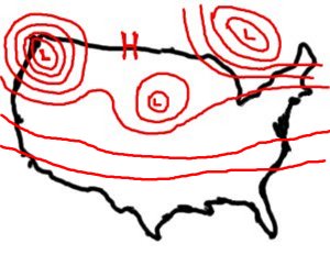 |