
METEOROLOGIST JEFF HABY
A dryline separates warm/dry air from warm/moist air. They are most common and most intense in the
spring and early summer season in the southern high plains region of the United States. A dryline advances forward by
mixing out the shallow layer of surface moist air ahead of it. This is accomplished by daytime heating
and the momentum of the wind behind the dryline. A low pressure cyclone with counterclockwise wind
can contribute to the momentum of the warm / dry air behind the dryline. At night the
PBL stabilizes since
daytime heating has ceased. At night the dryline will retreat back toward the source region
of the warm / dry air.
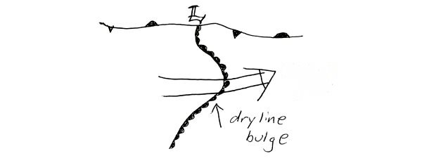
Tropospheric wind above the dryline will not be uniform across the entire dryline boundary. Surges of
stronger tropospheric
wind will advance the dryline forward along segment(s) of the dryline.
Low level convergence and
shear
is enhanced along this advancing segment. Dryline thunderstorms can be initiated by this convergence
enhanced uplift. The term for this advancing segment of a dryline is a dryline bulge. Below is a diagram
of a dryline bulge with stronger middle tropospheric wind advancing that segment forward.
|
|
|