
METEOROLOGIST JEFF HABY
The thermal low (also called a heat low) occurs due to intense daytime heating over a region. Typically
the synoptic pattern will be benign and the location will be in a dry land climate. Solar radiation strikes
the earth's surface and warms the troposphere from below. Dry lands such as those found in semi-arid
and arid regions warm up rapidly under sunlight since there is
little moisture from the soil or plants to
produce
evaporative cooling. The very hot air in the
boundary layer is inclined to rise since
warming air becomes less dense and more buoyant. When air rises over a region the surface pressure
will decrease just as pressure would decrease from lifting from a front or mid-latitude cyclone.
Typically the
dewpoint and relative humidity of the heated air in the boundary layer are low. This
reduces the amount of precipitation that occurs from thermal lows. Isolated storms or no storms at
all due to a
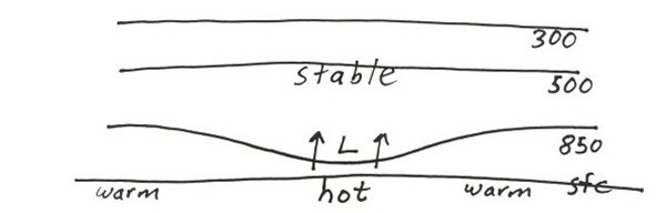
capping inversion are common. Stability aloft reduces the vertical depth of a thermal
low. The thermal low will be strongest at the surface but will weaken with height since the air is
rising at the greatest rate closer to the earth's surface. A thermal low will tend to stay in the same source region
it developed thus it will not transverse great distances like a mid-latitude cyclone will do. The diagram
below shows a thermal low in a vertical cross section:
|
|
|