
There are two types of inflow notches that will be discussed which are the low level inflow notch into the updraft of a storm and the mid-level rear inflow notch into the back side of a storm. The characteristic that both types of inflow notches have is that there tends to be reduced reflectivity in the region they occur since the air is either too dry or is moving too quickly to allow precipitation to develop or fall through this air. First will be shown a couple of examples of inflow notches into a supercell. Within the inflow region is the updraft. There tends to be lower reflectivities in the updraft region and higher reflectivities in the downdraft region. Within an inflow notch is the low level wind into the updraft of the storm. A classic supercell will take on a hook like feature and an HP supercell will take on a kidney bean feature. An example of each is shown below: Classic Supercell 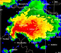 HP Supercell 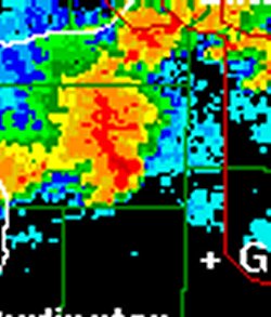 A rear inflow notch enters the backside of a storm in the middle levels of the troposphere. These inflow notches are particularly conducive to severe weather if they ingest high momentum and dry air into the storm. If the air is dry it will cool through evaporative cooling. This will increase the negative buoyancy of the air and it will accelerate toward the earth's surface. This negative buoyancy acceleration along with the air's initial high momentum can produce severe convective wind gusts at the leading edge of the storm or storm complex. An example of a storm complex with a rear inflow notch is shown below: 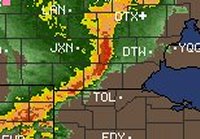
|