
The Bermuda high can have a significant influence on the weather in the USA. If the Bermuda high is strong and encompassing the southeast USA it can bring a prolonged period of dry weather. If the Bermuda high is further east then it can have the opposite influence since it will allow the Gulf of Mexico to "open up" to the USA. There are three important influences from the Bermuda high on bringing rain into the eastern USA. They are the influx of moisture, warm air advection and an increase in vorticity. The waters of the Equatorial Atlantic and Gulf of Mexico are very warm. Warm water will evaporate a large amount of moisture into the air. When the Bermuda high is far enough east the wind direction is perfect to bring in a large amount of moisture into the eastern USA. Low pressure systems moving in from the west can tap into this moisture and bring big rains. When the wind direction is from a southerly type direction, warmer air will brought in or the weather will continue to stay warm. Warm air from a moisture source will produce abundant precipitation when this air is lifted. Many afternoon thunderstorms and thunderstorm complexes occur as this unstable air is warmed and then lifted. Warm air advection is a lifting mechanism that can bring big rains, for example, along warm front boundaries. When the Bermuda high is far enough east it can transport in the heat and moisture without capping the atmosphere by the sinking air that a warm core high has. A south to north wind flow aids in the production of positive vorticity. Earth vorticity is a maximum at the pole and zero at the equator. As air moves north it gains earth vorticity. This can lead to more divergence aloft and thus rising air. The depiction below shows a portion of the Bermuda high off the coast of Florida and a low pressure trying to move in from the west. The area shaded in green is the prime area for precipitation. The area in green is far enough away from the high that the air will not be capped. This area is also seeing a transport of warmth and moisture from the Gulf of Mexico. As the low slides northeast it will be a lifting mechanism that will aid in the production of precipitation in the green area. The banding of precipitation on the edges of the Bermuda high are sometimes referred to as the ring of fire. If a weather pattern like this persists, flooding can occur. On future weather maps, note these features discussed in this essay when it comes to the position of the Bermuda high and the weather it helps bring into the USA. 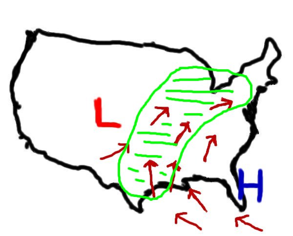 |