
Cumulus results from the convective lifting of air. When the visibility is clear, there is not a deck of low clouds, and there is intense convective from the surface then there is the setup to view some amazing cumulus congestus. Cumulus congestus is a developing thunderstorm cloud. The storm is in the developmental stage. In the developmental stage there may be no thunder, lightning or rain yet but by the looks of the cloud they will occur shortly. Cumulus congestus has been compared to cauliflower since they are both white with bulges. There are great bubbles and surges of moisture coming out of the updraft of air. There is an extreme moisture gradient between the air in the cloud and the air outside of the cloud. Since the cloud develops so fast, there is a nice contrast between the moisture laden cloud air and the dry clear air outside of the cloud. This contrast gives the cloud a crisp and vigorous appearance. Since the cloud develops so rapidly, there has not been time for the cloud air to mix out with the air surrounding it. Once the cloud air mixes with the surrounding air then the contrast will be less and the cloud will appear fuzzier. Once a cumulus congestus builds high enough, the top portion of the cloud will begin to freeze. This is the beginning stage of the development of the thunderstorm anvil. Since the anvil is made of ice particles, the anvil cloud will look much different than the cumulus portion of the cloud. The anvil will have a smooth and fuzzy appearance. Once the anvil forms then it is more common to begin to see lightning, hear thunder and see rain falling to the ground from the storm. At this point the cumulus congestus has become a cumulonimbus (a rain producing cumulus). The photo below shows a cumulus congestus cloud. Each of the towers is numbered 1 through 3 with comments on each tower. 1. This tower is fuzzier and not as vertically developed. This indicates a weaker updraft and an updraft that is losing its vertical momentum. The fuzziness can occur due to mixing with the surrounding air. 2. This updraft is crisp and very vertically developed. This indicates an established and active updraft. 3. This is also a crisp updraft. There also appears to be some glaciation (ice development) at the top of this convective tower. 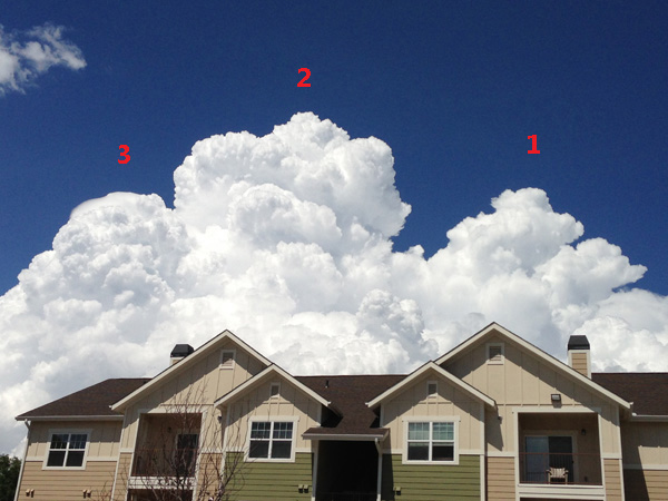
|