
| GENERATION OF A TUBE OF LOW LEVEL VORTICITY
| |||||||||||||||||||||||||||||||||||||||||||||||||||||||||||||||||||||||||||||||||||||||||||||||||||||||||||||||||||||||||||||||||||||||||||||||||||||||||||||||||||||||||||||||||||||||||||||||||||||||||||||||||||||||||||||||||||||||||||||||||||||||||||||||||||||||||||||||||||||||||||||||||||||||||||||||||||||||||||||||||||||||||||||||||||||||||||||||||||||||||||||||||||||||||||||||||||||||||||||||||||||||||||||||||||||||||||||||||||||||||||||||||||||||||||||||||||||||||||||||||||||||||||||||||||||||||||||||||||||||||||||||||||||||||||||||||||||||||||||||||||||||||||||||||||||||||||||||||||||||||||||||||||||||||||||||||||||||||||||||||||||||||
METEOROLOGIST JEFF HABY
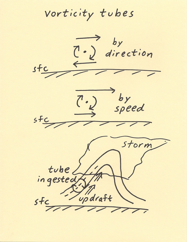
Vorticity is the spin imparted on the air. Changes in wind speed and direction will generate vorticity. In a severe weather environment,
changes in wind speed and direction are a factor to consider. An example of wind direction changing with height is a south wind at the
surface and a west wind at 700 mbs. Suppose a vertical axis is drawn. Over time, the changes in wind direction will twist the vertical
axis and this will generate vorticity. An example of a wind speed change with height is a 25 knot wind at the surface with a 50 knot
wind at 700 mbs. A vertical axis will also twist over time when there is a change of wind speed with height. The combined
influences of a changing wind speed and a changing wind direction at the same time will amplify the amount of vorticity generated. The
combined wind speed and direction change acts on a 3-D volume of air causing a volume of air to rotate. Tubes of vorticity can be
envisioned from these air motions.
When a thunderstorm develops, it will dramatically impact the vertical transport of air. The updraft occurs where air is rising due to
the release of instability. This vertical motion of air combines with the vorticity generated by changes in wind speed and direction
to produce a rotating updraft. The optimum conditions to produce a rotating updraft are strong winds in the boundary layer, speed
and directional wind shear and a strong updraft. With these factors in place, a tornadic environment is possible. Tornadoes may
or may not develop depending on a variety of other factors. The diagrams below show how wind speed and direction changes produce
low level vorticity and how this vorticity interacts with the updraft of a storm.
|
|
|