
| HABYTIME MINI LECTURE 13: THE INVERSION
| |||||||||||||||||||||||||||||||||||||||||||||||||||||||||||||||||||||||||||||||||||||||||||||||||||||||||||||||||||||||||||||||||||||||||||||||||||||||||||||||||||||||||||||||||||||||||||||||||||||||||||||||||||||||||||||||||||||||||||||||||||||||||||||||||||||||||||||||||||||||||||||||||||||||||||||||||||||||||||||||||||||||||||||||||||||||||||||||||||||||||||||||||||||||||||||||||||||||||||||||||||||||||||||||||||||||||||||||||||||||||||||||||||||||||||||||||||||||||||||||||||||||||||||||||||||||||||||||||||||||||||||||||||||||||||||||||||||||||||||||||||||||||||||||||||||||||||||||||||||||||||||||||||||||||||||||||||||||||||||||||||||||||
METEOROLOGIST JEFF HABY
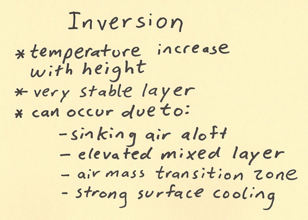
An inversion is a temperature increase with height. An inversion has a stabilizing influence within the region of the atmosphere it
occurs since warm air over the top of cooler air promotes stability. Often precipitation will not occur when an inversion is in place.
There are certainly exceptions though. For example, if the lifting occurs above the inversion, then precipitation can still occur. Another
example is air lifting over a warm front (isentropic lifting). Inversions can develop in a number of ways including: sinking air aloft
(sinking air warms adiabatically and makes it more likely there will be warm air above cooler air), an elevated mixed layer inversion
(this occurs when advection of a warmer air mass from a high elevation region occurs over a somewhat cooler air mass from a lower
elevation region), an air mass transition in the vertical (when warm air flows over cooler air (vertical boundary of warm front) or
when cooler air flows under warm air (vertical boundary of cold front)), and strong surface radiational cooling (earth’s surface at
night often cools more than the air aloft).
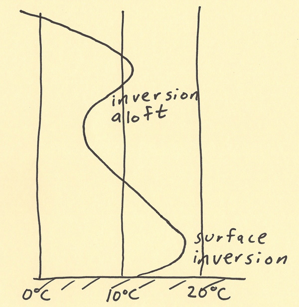
The diagram below shows an example of an inversion at the surface and an inversion aloft. Isotherms are along the bottom edge of the diagram
and the vertical axis is height. Notice at the surface and going up from there that the temperature is about 12 C and the surface and then
increases to a value of about 17 C above it. This warm air above cooler air is an inversion and it promotes stability between the surface
and where the temperature reaches a maximum aloft. Another inversion is drawn higher aloft. In fact, there is commonly an inversion at
the top of the troposphere. This is why thunderstorms can’t rise into the stratosphere. Between the troposphere and the stratosphere
is a strong inversion that impedes vertical motion.
|
|
|