
Snow is a common form of winter precipitation. Although it can cause problems, snow does have uncommon beauty and special characteristics. First, as snow falls on the ground it will full of air pockets. This allows for snowballs to be created and for this form of precipitation to build to a depth of several inches or more on the ground. Second, it was a distinct white appearance. Due to its fluffiness and the sun’s reflection off it, it has a beautiful appearance for pictures when it is falling and on the ground. For snow to reach the surface, the snow needs to develop aloft and also the temperature profile has to have temperatures that will support the snow falling all the way to the ground before it melts. Snow can still reach the ground when a shallow layer of air is above freezing or when the ground is above freezing. In these cases wet snow can fall (snow including partial melting of the snow) or snow melts once it reaches the ground. If snow partially melts aloft and then refreezes as it falls, it can reach the ground as a sleety snow. Generally, if snowflakes are seen in the air then the weather report will be of snow even if the snow is somewhat partially melted or melts on the ground as it falls. Snow does not have to accumulate in order for the current weather observation to include that it is snowing. The surface temperature does not have to be 32 F or below for it to be snowing. It is not uncommon for the surface temperature to be above freezing (i.e. 36 F) and for snow to be reported. This can happen since the snow did not have time to melt before falling through the above freezing layer to the surface. For the best snow accumulations it helps to have heavy snow, a ground surface temperature that is below freezing, for the snow to fall at night and for a low sun angle in daytime conditions. Snow is more difficult to measure than is commonly thought. Wind can significantly alter the amount of accumulation on various places of the ground. Snow will selectively accumulate better on some surfaces than others. Snow can change depth quickly due to compaction and melting. Snow can blow off of roofs and result in a higher accumulation at the ground surface. It helps to measure snow in an area free from obstructions and also to average the measurements over several places in the vicinity. Snow accumulation can vary depending on how measurement is taken and the accumulation can change quickly due to compaction. 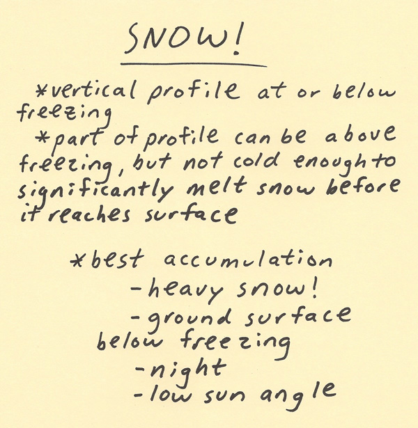 Below are three profiles and the how it relates to the falling snow’s liquid content and snow experienced at the surface. The dashed vertical line is the freezing point of 0 C. To the right of this line the temperature would be above freezing aloft and to the left of this line the temperature would be below freezing aloft. In the first profile, the entire profile is well below freezing. This will produce a drier and often fluffier snow. It will have a lower liquid water content thus it will be difficult to make snowballs with this snow and it will not be as sticky. This snow will accumulate very well though and since it is a fluffier it can accumulate inch by inch on the ground faster, especially if the snow is heavy. In the second profile, the profile is below freezing except right near and at the surface. This situation will produce a “wet snow”. This snow tends to be sticky and is great to make snowballs with. There is partial melting before the snow reaches the ground thus the snow will have a higher liquid water content. The ground is above freezing, thus some of the snow will melt once it reaches the ground. If the snow is heavy, the snow can accumulate even if the ground is above freezing. In the third profile, there is a shallow layer aloft of above freezing temperatures. The temperature only goes a little above freezing also. This situation can produce a “sleety snow”. The snow partially melts a little aloft and then the liquid content of the snow freezes again before it reaches the surface. The surface is below freezing thus this sleety snow will easily accumulate on the ground. 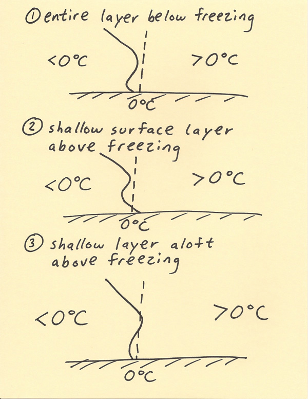 |