
Differential advection is the movement of different air masses over each other. The weather experienced at the surface can be very different as compared to the weather aloft. For example, the wind speed, temperature and direction can be very different even over a short vertical distance. An air mass is a synoptic size body of air with similar temperature and humidity aspects. When transitioning from one air mass to the next there is often an abrupt transition. This transition can not only happen at the surface but it can also happen in the vertical. For example, warm and moist air advecting over cool air. This is the differential advection pattern that can sometimes occur with a cold front. A cold front separates warm air from much cooler air and the transition zone at the surface between these air masses is the cold front. Commonly a cold front is associated with a mid-latitude cyclone. The cyclone is a synoptic vortex that brings air masses into proximity of each other. In the Northern Hemisphere, to the south or southeast of the cold front the winds tend to be from a southerly direction which helps drive in warmer air. If the wind is from an ocean, the south winds will also drive in humid air along with the moisture. To the north or northwest of the cold front the air is much cooler. Sometimes the skies will be cloudy with precipitation or storms near the cold front boundary. The wind direction shifts to a more northwest or northerly type direction north of the cold front. The cool air is sometimes shallow behind the cold front. Several hundred feet above the cool air there can exist warm air that is advecting over the top of the cooler air. The diagrams below show a cold front and associated winds at the surface and depict a cold front as a horizontal cross section showing the air masses/air mass transition zone aloft also. Note the wind direction shift from south of the cold front to north of the cold front. The winds are from a more northwesterly direction in the cool air northwest of the cold front while the winds are generally from the south or southeast in the region south to southeast of the cold front. The surface cold front is where the boundary between the warm and cool air intersect at the ground and is thus the point where a surface observer would note the frontal passage. In this example, the air to the south of the cold front rides (advects) over the cool air north of the cold front. Thus, an observer sampling wind direction with height to the north of the cold front would note a more northerly type wind at the surface but with a more southerly type wind aloft above the shallow cool air. This is an example of differential advection since an air mass shift along with a wind shift is occurring aloft. Since the air from the south is lifting over the shallow cool air, this is one reason why clouds and precipitation can occur along and just behind the cold front boundary. 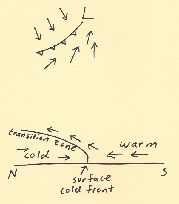 |