
The Lifted Condensation Level (LCL) is the level aloft in which air needs to be force lifted in order to become saturated. The LCL and CCL are important since they can be used to determine approximately at what elevation a cloud base will be located. The lifting is adiabatic. As a parcel of air rises, it cools. As the parcel cools, it increases in relative humidity. Once it raises enough for the relative humidity to increase to 100%, then the LCL is reached. The diagram below shows a representation of the dry adiabatic lapse rate and dewpoint lapse rate as they would roughly appear on a Skew-T diagram. In the troposphere, the dry adiabatic lapse rate is 10 C/km while the dewpoint lapse rate is 2 C/km. Even though both lapse rates result in a decrease of temperature (one being a dewpoint temperature), the dry adiabatic lapse rate decreases 5 times faster than the dewpoint lapse rate and thus as air rises adiabatically the temperature and dewpoint values will converge aloft. The diagram below shows the temperature and dewpoints approaching and then merging together as the parcel rises. The point where they merge together is the LCL. The diagram is representing very roughly what the process would look like on a Skew-T diagram where the temperature lines are slanted and not straight up and down. The Convective Condensation Level (CCL) is the level in which saturation occurs once the surface temperature warms to the convective temperature and then air rises adiabatically due to positive buoyancy. The convective temperature is the temperature the surface needs to be warmed to in order for air to rise on its own without being force lifted. An equivalent way for the process of finding the CCL is on a Skew-T diagram to follow the mixing ratio parallel and through the dewpoint until it intersects the temperature sounding aloft. Because the surface temperature needs to warm up first (which lowers relative humidity at the surface before the parcel rises), the CCL is at a higher level aloft as compared to the LCL for a location at the same time and place. The initial surface temperature and dewpoint will determine how much the air will need to rise before the LCL is reached. Air with a high relative humidity will not need to be lifted as much in order for saturation to occur as compared to air with a low relative humidity. High relative humidity air at the surface can lead to relatively low cloud bases while low relative humidity air at the surface can lead to relatively high cloud bases. Thunderstorms resulting from surface based convection will have a cloud base that is highly dependent upon the temperature and dewpoint characteristics at and near the Earth’s surface. The one big assumption during this writing is that the air behaves adiabatically. Due to the surface energy budgets and the wind mixing the air (boundary layer meteorology), the air at the surface has an adiabatic process that is highly contaminated. Because of this, on many LCL calculators, instead of using the surface temperature and dewpoint it will be the conditions at 50 mb above the surface that will be the starting point for uplift when calculating the LCL and other sounding parameters. 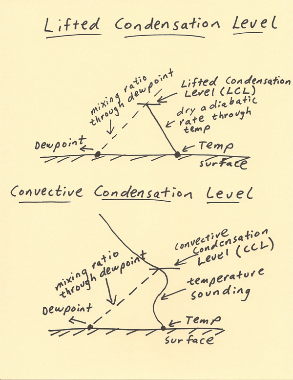 |