
| HABYTIME MINI LECTURE 39: ELEVATED CONVECTION
| |||||||||||||||||||||||||||||||||||||||||||||||||||||||||||||||||||||||||||||||||||||||||||||||||||||||||||||||||||||||||||||||||||||||||||||||||||||||||||||||||||||||||||||||||||||||||||||||||||||||||||||||||||||||||||||||||||||||||||||||||||||||||||||||||||||||||||||||||||||||||||||||||||||||||||||||||||||||||||||||||||||||||||||||||||||||||||||||||||||||||||||||||||||||||||||||||||||||||||||||||||||||||||||||||||||||||||||||||||||||||||||||||||||||||||||||||||||||||||||||||||||||||||||||||||||||||||||||||||||||||||||||||||||||||||||||||||||||||||||||||||||||||||||||||||||||||||||||||||||||||||||||||||||||||||||||||||||||||||||||||||||||||
METEOROLOGIST JEFF HABY
Convection is a process in which air rises due to positive buoyancy (being less dense than surrounding air). In a typical
thunderstorm situation, convection begins from near the Earth’s surface and rises throughout the troposphere. Elevated convection
is convection that begins aloft such as from the 850 mb level. This can happen when the boundary layer at the surface has stable
air but there is a layer of unstable air aloft such as warm and moist air advecting into the area aloft but not at the surface.
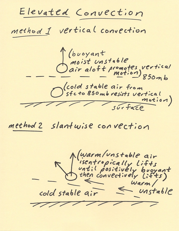
Elevated convection can range from upright convection to slantwise convection. Upright convection is the air parcel buoyancy lifting
vertically upwards from the surface. Slantwise convection is the air parcel buoyancy lifting at an angle as it rises. The diagram
below shows these two methods. Method 1 shows vertical convection where the convection is initiated around 850 mb. Method 2 shows an
isentropic lifting pattern over cold stable air at the surface. The warm moist air is advecting and lifting over the cold stable air.
Typically, convection is thought of as a vertical process. The indices such as CAPE, LI SWI (Showalter) assume this upright vertical
convection process and thus the CAPE, LI, SWI (Showalter) are calculated this way on a Skew-T sounding. However, it is possible for
all the (in)stability indices to indicate no instability is present above a location, yet convection still occurs from the process
known as slantwise convection. Slantwise convection occurs at an angle. A common situation for slantwise convection to occur is when
warm and moist air advects over a warm front boundary. North of the warm front boundary the air at the surface is cool and stable.
The depth of this cool air increases with distance ahead of the warm front. Thus as the warm and moist air advects over the warm
front it continues to advect to higher altitudes by isentropic lift over the cold stable surface air. While the warm and moist air
is on this trajectory it is possible that it will move into an environment in which the air will not only continue to isentropically
lift, but will convectively lift. The gentle upglide of the air will suddenly become a rapidly convective uplift (process shown on
method 2 below). These types of situations are responsible for producing heavy bands of snow and thundersnow north of a warm front
boundary or in other situations where moist air is differentially advecting over stable cold surface air.
|
|
|