
The temperature profile in the vertical is a critical factor in determining the wetness of snow. Wet snow generally has a snow depth to melted liquid depth ratio of less than 10. Dry snow generally has a snow depth to melted liquid depth ratio of greater than 20. Values between 10 and 20 are a hybrid of the two. Wet snow is great for making snow balls and it is a sticky snow. Dry snow is powdery, easily blown around by the wind and is not sticky. What determines the wetness or dryness of the snow is the amount of liquid content within the falling snow. When the temperature aloft goes just above freezing (see diagram below) then some of the snow will melt and it will fall as a wet snow. In the dry snow profile the temperature is well before freezing and thus the snow will have a low liquid content. Other factors that influence the wetness of snow are day vs. night, ground temperature, and if the sun is out. Even in cloudy conditions, some sunlight passes through clouds. Some of this light absorbs into the falling snowflakes and thus this can make a snow wetter even at temperatures well below freezing. This does not happen at night thus all being equal a night snow will be a little drier. If the ground surface is above freezing, some or all of the snow will melt after it reaches the ground. This will make a snow wetter. Sun shining on snow on the ground, even when temperatures are well before freezing, will cause snow to become wetter due to the absorption of solar energy into the snow. At night, when temperatures fall below freezing then snow on the ground will tend to have its liquid water content freeze up and the snow will become a hard crusty snow. 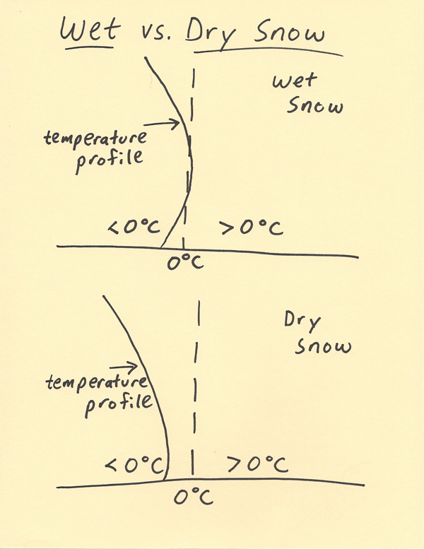 |