
The Alberta Clipper is a lee-side low generated in the province of Alberta, Canada. Although it is named for Alberta, the low pressure system can influence regions well to the east and southeast of Alberta. Thus, the low is named for where it is generated and not for the region it impacts. Clipper systems can impact regions of Canada east of Alberta and the northern regions of the U.S. east of Montana. The diagram below shows an Alberta Clipper and a track it can take toward the east and southeast. The Alberta Clipper, generically known as a clipper system, most commonly occurs in winter. A lee-side low is generated as the wind flows over the Rocky Mountains of Alberta, Canada. This low then follows the upper level winds toward the east and southeast. As the low moves toward the east and southeast it generates fronts. The cold front can help usher in cold and windy conditions as the system moves. Clipper systems typically generate light to moderate snowfalls but not heavy snowfalls. There are two reasons for this. First, moisture sources are far away. Second, clipper systems tend to move fairly rapidly. The term “clipper” comes from fast moving ships of the same name. Clipper systems do bring in significant changes to the weather since they do bring in some snow and help drop down colder air toward the south in their wake. If a clipper system moves over the Great Lakes it can help enhance lake-effect snow. Watch for clipper systems during the winter months. They can produce quick changes to the weather and usher in snowy and windy conditions. The snow tends to be light but the strong winds can produce blizzard conditions due to the cold temperatures, strong wind and blowing snow. 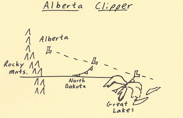 |