
Storms that move into the west coast of the United States are most common in the late fall, winter or spring. The Pacific Ocean is a huge reservoir of moisture. In the cooler half of the year, the jet stream is displaced farther to the south and is thus better able to tap into moisture over the Pacific Ocean that can produce storms that move into the U.S. west coast. Low pressure systems generally move from west to east thus the storms move into the west coast from the ocean. The northern portions of the coast get hit more often since the jet stream position tends to be closer to this region. The west coast of Washington and Oregon are known for the abundance of precipitation that is received each year. Mountains ranges are common along the west coast. Because of this the heaviest precipitation tends to occur from the coast, across the windward mountain slopes and on the mountains. The eastern side of Washington, Oregon and California in locations of lee facing mountain slopes tends to be much drier. This is referred to as the rain shadow effect. The image below shows a low pressure storm approaching the west coast of the U.S. The numerous height contours indicate a well developed low pressure system. These storms typically move in from the west or northwest and bring in wind and heavy precipitation. 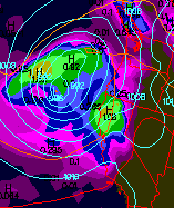 |