
METEOROLOGIST JEFF HABY
A shortwave is a small trough that can bring an increased chance for precipitation. The shortwave will have a sharp curvature in
the flow pattern. This sharp curvature introduces a vorticity or spin to the air. This is associated with upper level divergence
and rising air. Shortwaves can also develop due to flow over a mountain range, along a frontal boundary and with a developing
surface low pressure system. These mechanisms produce rising air. Since rising air cools, heights will fall aloft and will fall
the most where the rising air is maximized. This produces a kink in the height contours aloft that can lead to the generation
of positive vorticity. Flow through the curved height contours will produce positive vorticity advection downwind from the
vort max (vort max defined as the center of region of highest vorticity). Shortwaves have important forecast implications
since they bring in an increase of cloud cover and increased precipitation chances.
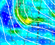
The model image below shows a shortwave over Idaho. Notice the cyclonic kinking of the height contours over Idaho. This is aiding in
the generation of vorticity (shown in yellow). Flow through this region of vorticity produces positive vorticity advection
downwind from the trough axis. Positive vorticity advection is associated with upper level divergence and rising air. Regions
downwind from the center of the vorticity region (such as southeast Idaho) have increased cloud and precipitation chances.
|
|
|