
November 30, 2006: A large winter storm barreling out of the southern Plains toward the Ohio Valley targets the Midwest with rain, ice and snow. In Illinois, the state’s midsection is coated in a glaze of frozen precipitation before record daily amounts of snowfall are measured the next day. This event of freezing rain, followed by heavy snow, paralyzes the city of Peoria and neighboring communities for days. Rural counties are left without power because of downed power lines; businesses and airports are closed; ice and snow-covered roads make for hazardous travel and ultimately central Illinois is declared a federal disaster area. Total damages from that particular event in central Illinois totaled nearly $20 million! There is little doubt that ice events, like freezing rain, can have a devastating and lasting effect on mankind. Freezing rainstorms in the United States from the year 1949 to 2000 resulted in losses totaling $16.3 billion (Chagnon 2003). Ice is one weather phenomenon that is all too familiar in central Illinois. 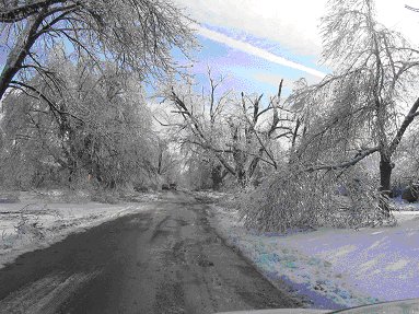 This picture was taken on December 1, 2006 by Chris Neaville of Mt. Pulaski, Illinois Neaville, a trained cooperative weather observer, measured ice thickness of 1.5” (Picture reprinted with permission from Chris Miller, NWS Lincoln) Freezing rain occurs when liquid rain falls through a shallow subfreezing layer of air near the ground (Lutgens and Tarbuck). Rain is cooled as it falls through the freezing layer near the surface of the earth. When supercooled liquid strikes the ground that is already below freezing, it freezes on contact. 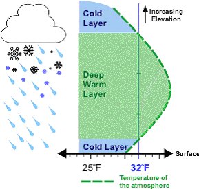 How Freezing Rain Forms in the Atmosphere (Illustration Provided by NWS Lincoln & Reprinted with Permission) The end result is ice accumulation on just about everything: roads, yards, buildings and electricity lines. Looking back at local climatology records, freezing rain most typically occur in central Illinois between November and April. State experts say severe winter storms in Illinois produce more total damage than any other form of short-term severe weather event including tornadoes, hail and lightning (Angel). Even worse, this region has the dubious distinction of being in the nation’s primary area for severe freezing rainstorms (Hilberg & Angel). A 2004 study written by Climatologist Stanley Chagnon examined the temporal and spatial distribution of ice storms in the Midwest. His report revealed that from the years 1948 to 2000, the highest frequency of days annually with freezing rain in the Midwest (5 days a year) occurred along a west to east zone from Missouri eastward to Ohio that included central Illinois. 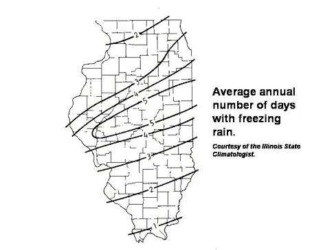 Furthermore, central Illinois was grouped in an area that averaged the highest number of days a year (7) with sleet from the year 1901 to 2000 (Chagnon, 2004). Illinois State Climatologist Dr. Jim Angel says on average Illinois will experience 15 severe ice storms over a ten-year period. A large reason for the high frequency of ice storms in central Illinois simply has to do with the state’s geographic location in North America, putting it in the path of many storm systems. Two different synoptic weather conditions stand out as producers of ice. One weather pattern often associated with freezing rain is the Arctic front (Rauber et al.). Arctic frontal storms cause one third of all freezing rain events in the Midwest (Chagnon & Kunkel, 2006). These fronts move southward across North America during the winter. When warm moist air out of the Gulf of Mexico rises over advancing cold air from Canada, it creates clouds that result in freezing rain and sleet. A second weather pattern that produces many freezing rain events in the Midwest occurs north of a warm or stationary front associated with a winter cyclone. Chris Miller, Warning Coordination Meteorologist with the National Weather Service in Lincoln, Illinois (KILX) confirms Chagnon’s opinion, adding the cyclogenesis of a winter storm should be evaluated when forecasting ice. In his experience, a winter cyclone that develops in the southern Plains, near the Oklahoma and Texas panhandles or better yet, a storm that originates in Colorado is more likely to produce ice over central Illinois, compared to one that travels south out of the Canadian prairie (i.e. “Alberta Clippers”). Supporting these statements is a map, provided by the Illinois State Climatologist’s Office that outlines the five leading storms influential during Illinois’ winter season. The five storm types are based on the source of the storm, and the track the storm follows. 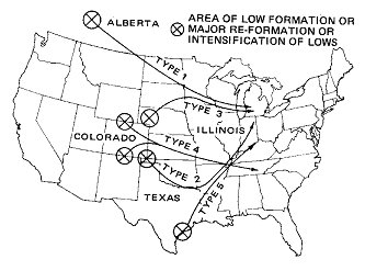 © Illinois State Climatologist Office (Reprinted with Permission) “The most damaging storms, on the average, are those that originate in Colorado and end up moving just south of Illinois (Types 2 and 4 on the map)” (Hilberg and Angel). What makes these types of storms difficult to forecast is often the temperature of air masses interacting with the system. A matter of a few degrees, not only at the surface, but in a layer of air several thousand feet aloft, will determine whether snow or ice will fall. Colorado lows (Type 4) and Oklahoma Panhandle lows (Type 2) result in a continued flow of warm air aloft into the northeast quadrant of the surface low. This warm air may be modified, becoming cooler as it moves northward and as it experiences strong vertical motion associated with the storm. It is this delicate balancing act between the flow of warm air, and the cooling it may undergo, which makes forecasting ice storms difficult. Illinois State Climatologist Jim Angel says the severity of an ice storm is dependent upon three variables: 1) the amount of rain taking place, 2) wind speed, and 3) whether the storm strikes an urban or rural area. Ultimately, ice storms can present a number of negative consequences on life and property. First, traveling becomes hazardous. Streets and highways are impassible. More traffic accidents occur. That leads to schools and businesses closing. Jets and runways covered in ice force airports to close. Postal carriers are forced to halt delivery of mail. The weight of ice over time can snap trees and electric lines, causing extended power outages. The lack of electricity not only adversely impact homeowners, but parents with school closures. Ice storms can also have a negative economic impact on communities when businesses are forced to close. One example of the aforementioned is from Ameren Incorporated, a major utility company in Illinois. The company reported more than 40,000 utility customers in Decatur alone were without power up to eight days after the November 30th ice and snow event. (The population of Decatur is about 81,000.) Besides electric companies, there are large costs incurred on state and local governments for the salt necessary to melt ice and snow. According to Street and Sewer Manager David Haste, the city of Peoria used a record 15,990 tons of salt to clear the roads of ice and snow during the 2006 winter season. In summary, the impact of ice is a ripple effect. Awareness and experience can improve forecasting ice storms. First, the public as a whole should heed a meteorologist or forecaster’s warning of an impending storm. Being proactive, staying indoors and off the roads can help public works and transportation departments clear routes for travel, limiting the loss of economic revenue and injury. Although weather forecasting has improved significantly in recent years, meteorologists still struggle with predicting when and where storms will develop. Experience, along with improved forecasting technology over time will help pinpoint the timing and location of ice events. Works Cited Changnon, S.A. 2003. Characteristics of Ice Storms in the U.S., Journal of Applied Meteorology, 42: 630-639. Lutgens, F. and E. Tarbuck. 2004. The Atmosphere: An Introduction of Meteorology. 9th Edition. Prentice Hall, Upper Saddle River, New Jersey. Hilberg, S. and J. Angel. 2006. The Cold Hard Facts about Winter Storms. Illinois State Water Survey. On the Web: http://www.sws.uiuc.edu Chagnon, S.A. 2004. Climate Atlas: Freezing Rain and Ice Storms. Chagnon Climatologist, Mahomet, Illinois. Rauber, R.M., Olthoff, L., Ramamurthy, M.., Miller, D., and K. Kunkel. 2001. A synoptic weather pattern and sounding-based climatology of freezing precipitation in the U.S. east of the Rocky Mountains. Journal of Applied Meteorology, 40: 1724-1747. Chagnon, S.A., and K. Kunkel. 2006. Severe Storms in the Midwest. Illinois State Water Survey, Contract Report 2006-06, Champaign, Illinois. |