
Anchorage, Alaska is located in South Central Alaska, northeast of the Alaska Peninsula, due north of the Kenai Peninsula, northwest of Prince William Sound and the Alaska Panhandle, and nearly due south of Mount McKinley. The Anchorage "Bowl" is a strip of coastal lowland extending up the slopes of the Chugach Mountains to the east. To the south, lies the Turnagain Arm, a fjord with some of the world's highest tides. The Knik Arm, another tidal inlet, lies to the west and north. The following locations encompass the Anchorage bowl; Anchorage, Elmendorf AFB, Fort Richardson, Eagle River, Birchwood, Peters Creek, Eklutna (most northern town), Girdwood, and Portage (most southern town). 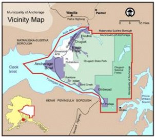 When most people think of Alaska they think of lots of snow for most of the year, however; Anchorage only averages about 70.5 inches of snow a year. Alaska winters begin in late October and usually end in early April with the most snow occurring from December to February. Forecasting snow in the Anchorage bowl can be difficult at times due to the geographical features that surround the region. The mountains to the east can easily hinder moisture moving into the bowl and a majority of the time precipitation will only fall on the windward side of the range. Wind flow along the Chugach mountain range usually produces a downsloping feature that brings strong warm air advection to the region. When the wind flow is from the north-northeast, the flow passes through valleys and passes which allow moisture into the bowl. The atmospheric feature that sets this type of flow up is known as the Broad Longwave Trough with Transient Shortwave Troughs regime. The Broad Longwave Trough with Transient Shortwave Troughs regime usually sets up 15-20 times a year with most of the occurrences happening during the winter. The winds aloft tend to be light and the pattern usually sets up with the trough line along or just west of 150W. This regime is the primary snow producer for the Anchorage bowl and 1-2 times a year a Prince William Sound Low will develop as one of these transient shortwave troughs move through the region and into the sound. When a Prince William Sound low sets up the forecaster for the Anchorage Bowl will have to track the system very closely since the position of the low can have a great impact on snowfall amounts. 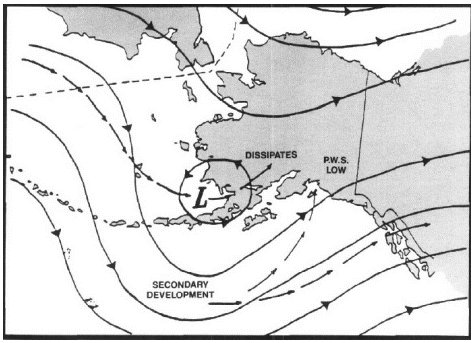 The broad longwave trough will need to be oriented to the west of Anchorage for a Prince William Sound low to develop and have any influence on Anchorage. This allows the low to approach the Anchorage bowl from the southwest. As the system approaches the winds will shift to a more north to northeasterly direction bringing in needed abundant low level moisture. The broad longwave trough lying over western Alaska provides instability, moisture advection, and cold air advection to the Anchorage bowl. The longwave trough has very little movement and tends to remain for a week or more. Maintaining continuity of the trough axis is critical with this pattern as it often retrogrades. The weather to the west of the trough axis is usually fair, stable, and cold while the weather to the east is unsettled and unstable. The typical shortwave trough propagating through the nearly stationary longwave trough will normally track from the Bering Sea toward mainland Alaska then into the north Gulf of Alaska. These shortwave troughs can bring rapid weather changes in short time as they progress across the state. The shortwave troughs that the forecasters in the Anchorage bowl are concerned about are the ones that track into the Prince William Sound. Depending on the actually track of the low the bowl can see up to 20 inches of snow in a very short time, usually less than 24 hours. Typically before the shortwave trough approaches, there will be significant cold air advection over the Anchorage bowl. The cold air usually pushes south into the Prince William Sound causing increased instability as this colder air lies over the relatively warmer waters. The approaching shortwave trough will then tend to move into this region of greater instability. As the shortwave trough moves into the northern Gulf of Alaska a surface low will develop. The shortwave trough will slow and typically begin to fill as it continues to push east into anti-cyclonic flow, where the longwave trough begins to transition into the longwave ridge, and the surface feature will move into the Prince William Sound. The upper level feature will continue to push east to northeast and fill or dissipate while the surface low will stall in the sound as it gets caught up in the mountainous terrain on shore. The tracking of the low will be a major factor on determining how much snow will fall in the Anchorage bowl. If the low tracks in the eastern half of the sound very little or no snow will accumulate in the bowl. If the low tracks in the western half of the sound snow will occur with the greatest snow fall amounts happening when the low tracks along the western shore of the sound. The models, unfortunately, do not normally handle the tracking of the surface low very well so the regional forecaster really needs to use metsat and radar to help with the tracking of the low and approaching precipitation. After the upper level feature has outrun the surface feature the surface low will begin to fill as it no longer has upper level support. Snow usually begins as the surface low develops or moves into the north Gulf of Alaska with the heaviest snow and greatest snowfall amounts occurring as the system begins to fill. The faster the system fills the greater the snow fall amounts will be. Snow fall continues until a significant synoptic change occurs, the low fills entirely, or until low level ridging or upper level divergence becomes prominent. After reviewing snow fall amounts associated with Prince William Sound lows at Elmendorf AFB it appears that 10-25 inches of snow are not uncommon. Due to the system begin very uncommon and hard to forecast for there is very little written about the feature. After talking to some civilian Air Force forecasters that have been forecasting the weather for the Anchorage bowl for nearly 10 years I have come to the conclusion that there is still much controversy as to what an actual Prince William Sound low is and how they develop. After my review and 3 year forecasting experience at Elmendorf, I believe that the Prince William Sound low is one of the hardest weather features to forecast for. The low position, the strength of the upper and low level features, and the amount of moisture available all play a role in the potential development of a possible Prince William Sound low. I believe the biggest help with trying to forecast this feature will be using the metsat and radar to track the system and incoming precipitation. The metsat loop will assist with the tracking of the low especially when the low position can have such an influence on the snow fall amounts. The radar will assist in tracking the heaviest snow. |