
“A squall line or instability line located in the warm sector of a wave cyclone, about 50 to 300 miles (80 to 480 kilometers) in advance of the cold front, usually oriented roughly parallel to the cold front, and moving in about the same manner as the cold front. Also called non-frontal squall line; pre-cold-frontal squall line (answers.com).” Basically translated, a squall line is a very long, narrow band of showers and thunderstorms, sometimes severe, but it’s not a very wide band of weather. It is usually several times longer than it is wide based on the dynamics of its formation. Then you may ask, what are the dynamics and under what conditions does it form? The dynamics and conditions with which the pre-frontal squall line occurs are under a generally accepted theory which follows: “… that as thunderstorms develop along the fast moving cold front, large quantities of cold air from aloft descend in downdrafts along the front and form a wedge of cold air ahead of the front. The wedge of cold air then serves as a lifting mechanism for the warm, moist, unstable air; and a line of thunderstorms develops several miles in advance of the front (tpub.com).” Squall lines typically occur in the southern United States, east of the Rocky Mountains and most often occur in the spring and summer months (tpub.com). This would make the most sense with the smoother topography at play east of the Rockies enabling these types of cold fronts to sweep over the fairly flat terrain and have the dense, cold air push down and out ahead of the front to form a pre-frontal squall line. Within this line, there will be numerous perils associated with this system. The types of weather phenomenon associated with pre-frontal squall lines typically are heavy rain showers and thunderstorms, hail, and tornadoes are possible if the warm air mass is extremely unstable (tpub.com). These may be short lived in a thin squall line or there could be a wider squall line and the weather would persist a bit longer. And in some rare cases, more than one squall line may form. Each situation is going to be unique and keeping a record or a journal of events can help a meteorologist determine the type and severity of each event in the future. The type of damage it can do is unprecedented: devastation to aircraft, crops, homes, people, and live-stock are all susceptible to damage and destruction that severe weather usually entails. This could be hail of a small to large size, strong gusty winds that blow over your fences and take part of your roof off, lightning that strikes your home and catches your abode on fire, flash flooding if the storms train over your area and the surface was recently saturated, or the extraordinary occurrence of tornadic activity that tears your home, possessions, and your lives to shreds. Severe weather is nothing to sneeze at; we must always be on the lookout and take appropriate cover from the storm. No matter the size, it is still a dangerous and powerful entity with no regard for life or possession. This leads us to our next inquiry: How does a squall line move? That is a good question. These systems tend to move the same direction as the cold front is moving. The speed can be faster than the cold front, at times. The speed at which they move is approximately 40% of the 500mb wind field, as a general rule of thumb (tpub.com). Based on this, a forecaster should be able to look at the latest 500mb chart and try to determine wind speed and direction of the squall line. If one is not available, try your area’s latest Skew-T sounding and strive to make your determination of the movement and speed from that source. Below is an example of how a prefrontal squall line may form in front of swiftly moving cold front. 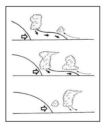 Figure 4-34.—Prefrontal squall line development (tpub.com). Here in south Mississippi, we are in a unique position and have experienced many prefrontal squall lines. Primarily due to our latitude and topography we are prone to be in the warm sector of a mid-latitude cyclone and have the low level jet set up in our vicinity in advance of a strong cold front. Then, when the cold air begins to funnel into our area ahead of the front, we see the clash of the air masses at its greatest right here. Subsequently, we will see squall line forming to our west and move in an easterly direction bringing with it showers and thunderstorms with heavy rain and frequent lightning. It is good if the weather forecasters for our area stay on top of the situation and alert the public via television and radio broadcasts of the possible weather threats, so that they can take the appropriate actions regarding their personal property and person. The majority of the time in our northern viewing areas, as far north as Jackson, MS, will receive more precipitation than the southern viewing areas. I believe this is due to the fact that the moist air that is transported north from the low level jet clashes more dramatically than here along the beach front. Also a factor, that being this far south we see the tail end of cold fronts most often and the majority of the inclement weather usually rides further to the north and we will receive a lesser extent of the heavy rain showers and thunderstorms provided by the squall line. Most of these systems do occur during the spring and summer months, primarily spring here in the South Mississippi due to the clash of the Continental Polar (cP) air masses moving into our typical Maritime Tropical (mT) air mass that readily sits atop our area. This event is going to be hard to forecast due the fact that the meteorologist is going to have to determine the strength of the particular cold front and the properties of warm, moist air mass out ahead of the front. Then monitor the surface observations out ahead of the front and see if a line of thunderstorms appears to forming and determine the 500mb wind speed and direction to further aide in determining the strength and movement of the squall line. Each system will have its own unique fingerprint and as I mentioned above, keeping a journal may help the forecaster to keep track and then, climatologically come up with a first forecast. Below are a few examples of squall line images found from various websites. A shelf cloud such as this one can be a sign that a squall is imminent (wikipedia.com) 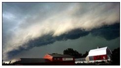 Squall line enters Collin County (outlined in white) from the north on Sunday, August 25, 2002. Image courtesy of the National Weather Service (Yahoo Images Search). 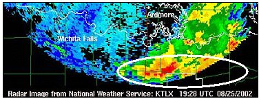 Showing the typical pressure and precipitation field around a squall line. From the COMET web site at http://meted.ucar.edu/ of the University Corporation for Atmospheric Research (UCAR) funded by the National Weather Service. ©2000 UCAR (Yahoo Images Search). 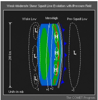 Works Cited Page Integrated Publishing. "Instability & Squall Lines." Integrated Publishing: the Most Informative Site on the Internet. 1998. Department of the Navy. 07 Mar. 2008 http://www.tpub.com/content/aerographer/14312/css/14312_122.htm. McGraw-Hill Companies, In. "Sci-Tech Dictonary: Prefrontal Squall Line." Answers.Com. 2003. McGraw Professionals. 07 Mar. 2008 http://www.answers.com/topic/prefrontal- squall-line?cat=technology. Riusabruce, Et Al. "Squall Line." Wikipedia: the Free Encyclopedia. 08 Mar.-Apr. 2008. 11 Apr. 2008 http://en.wikipedia.org/wiki/Squall_line. Ted, Best. "August Squall Lines Visit Collin County." Yahoo Images Search. Ed. Goldblatt Berry. 10 Sept. 2002. 11 Apr. 2008 2Bof%2Bsquall%2Blines&w=200&h=149&imgurl=www.k5prk.org%2Fimages%2Fnews% 2F2002TedBestKD5JEOAugSquallLinesPix.jpg&size=7.1&name=2002TedBestKD5JEOAugS quallLinesPix.jpg&rcurl=http%3A%2F%2Fwww.k5prk.org%2Fprint.php%3Fid% 3D76_0_8_0&rurl=http%3A%2F%2Fwww.k5prk.org%2Fprint.php%3Fid% 3D76_0_8_0&p=squall+lines&type=jpeg&no=3&tt=9%2C518>. |