
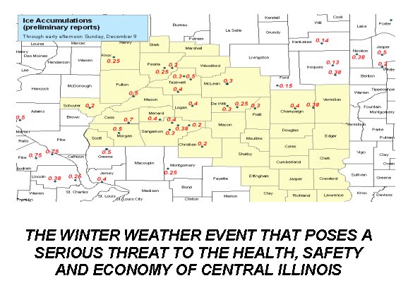
 "I'd rather have a foot of snow than a sheet of ice!" That was the proclamation of a viewer one afternoon this past winter while I was standing in the checkout line of a local supermarket. As a weather anchor on local television you become accustomed to people commenting on the weather in all sorts of locations and situations. Considering the impact that ice from freezing rain has had on central Illinois the past few winters, it should come as no surprise that the sentiments of that viewer are shared by many in the "Land of Lincoln". Forecasting winter precipitation of any kind is the most formidable of tasks faced by a meteorologist. Freezing rain, in particular, can be regarded as the most difficult winter weather event to forecast. It gets that distinction for several reasons. The smallest of temperature changes in the vertical profile of the atmosphere can quickly alter the form of wintry precipitation from freezing rain to sleet, snow or rain. Its area of formation is often very small in narrow bands of less than 50 kilometers (30 miles) wide.(1) Because of those two factors, freezing rain occurs less frequently than other forms of winter precipitation. Freezing rain can occur, on average, a total of nine to twelve days each winter season in the upper two-thirds of the state of Illinois.(2) The most dangerous freezing rain event has ice accumulations of a quarter of an inch or greater. When that amount of ice is forecast, the National Weather Service will issue an "Ice Storm Warning" for the affected forecast area. Freezing rain events producing smaller accumulations of ice, however, are still capable of causing potential hazards to personal safety and property. Freezing rain and the ice it leaves behind can be deadly. About 70% percent of deaths related to ice and snow occur from automobile accidents on icy roads. Additional deaths are brought on due to hypothermia. Among those who die from exposure to cold, about 20% of the deaths occur in the home.(3) Often those homebound deaths are elderly victims who are exposed to freezing temperatures as the result of the power being out in their home for several days after an ice storm. Numerous injuries, such as sprains and broken bones, also happen as the thin layers of ice on smooth surfaces are often "invisible" to the human eye. A heavy economic toll is also exacted by a major freezing rain event. Falling tree limbs can cause serious damage to roofs and shatter the windows of homes and businesses. Falling tree limbs and the weight of ice on power lines can cause extensive and lengthy power outages and cost utility companies millions of dollars for replacement materials and overtime pay to line workers working around the clock for days at a time to restore power. Governmental units spend additional tax dollars to salt and de-ice roadways and provide public safety through first responders. Non-profit organizations like the American Red Cross or Salvation Army are called upon to provide shelter and food for families needing a warm place to stay until power and heat is restored. Many businesses also suffer by not being able to conduct business as usual. Winter storms with freezing rain as the main precipitation threat have wreaked havoc on a number of communities in central Illinois the past three winter seasons. The most recent ice storm to hit was on the weekend of December 8 and 9 of 2007. Jacksonville, Illinois and surrounding communities in Morgan County were hit especially hard with ice accumulations of around half an inch. Roads were covered with a sheet of ice that made for dangerous driving conditions and contributed to numerous accidents, mainly "fender benders". Tree limbs and power lines snapped under the weight of the ice and plunged many residents into darkness. Of the nearly 16,000 customers of Ameren/Illinois Power in the city and county, nearly 10,000 were without power on Sunday afternoon.(4) For many of those customers, power wasn't restored until well into the middle to late part of the week. Winter storms that take aim on central Illinois develop in two distinct locations.(5) The first area is in southeastern Colorado where low pressure begins forming in the lee of the Rockies. The other is also in the lee of the Rockies, but located farther north in Canada's Alberta province where it earns the nickname "Alberta Clipper" for its oftentimes fast moving progression. Of the two, it's the so-called "Colorado Low" that can be the most potent mid-latitude cyclone winter weather maker for central Illinois. Its storm track into the southern plains and on into the Midwest allows it to tap into maritime tropical air out of the Gulf of Mexico. Maritime air provides the moisture and warm air advection that helps in the development of freezing rain. The terms "freezing rain" and "sleet" are often confused and considered to be the same thing by the general public. The two forms of winter precipitation share the same, basic concept of development. Snow melts as it falls through an inversion of warmer air aloft before it finally enters a layer of surface air that is at, or below, freezing. But, that's where the similarities end and the difficulty of forecasting freezing rain begins. Sleet forms as the result of snow partially melting through a layer of air aloft that is above freezing. The precipitation then enters a deep layer of air that is at, or below, freezing in the surface layer and it freezes into small ice pellets that range in size from 0.5 mm to 5 mm in diameter.(6) While sleet isn't large enough to cause any significant damage, the accumulation of sleet can make travel hazardous. Freezing rain, like sleet, occurs when snow falls through a layer of air aloft that is above freezing. Unlike sleet, it completely melts as it moves through this warmer layer of air and becomes supercooled as it moves into a shallow layer of air in the surface layer that is at, or below, the freezing level of 0*C (32*F). Once the precipitation reaches the surface, it quickly freezes into a thin layer of ice known as "glaze". Over time, this layer of glaze can accumulate from 1 cm to 2 cm in thickness.(7) In forecasting freezing rain, it's critical to evaluate the layers of the atmosphere by analyzing sounding data of the skew-T chart to assess the likelihood of freezing rain. If a sounding has temperatures at, or below, freezing throughout the entire profile, the precipitation will be snow. Conversely, if the sounding has temperatures above freezing throughout the entire profile, the precipitation will be all rain. It's the profiles that fall between those two extremes that determine whether the forecast will include sleet or freezing rain. A sleet profile will typically have a shallow layer of warmer air aloft and a deeper layer of air at, or below, freezing in the surface layer. Meanwhile, the temperature profile for a sounding depicting freezing rain will show a deeper layer of warmer air aloft and a shallow layer of air at, or below, freezing in the surface layer. In assessing a sounding for the potential of freezing rain, a good "rule of thumb" is to look for a cold layer about 1,500 feet thick near the surface, a warm layer about 5,000 feet above the cold layer, and, of course, surface temperatures of 32*F or less.(8) 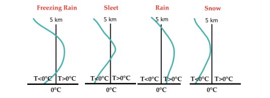 In addition to the sounding profile, a review of the 850mb to 750mb charts is important in assessing warm air advection or cold air advection. Too much warm air advection has the potential to mix out the surface layer of cold air and turn the precipitation over to rain. On the other hand, cold air advection and/or evaporative cooling can have the opposite effect of deepening the cold surface layer and thinning the warmer layer of air aloft to begin the transition to sleet and eventually to all snow, once the warmer air aloft drops below freezing. In the future, higher resolution computer models, more advanced radar systems and satellite programs, such as the COSMIC network (9), along with recent improvements in weather balloon soundings and more research into atmospheric processes will combine to provide a better understanding and improvement in forecasting capabilities of freezing rain events and other winter weather events. REFERENCES 1. The "Weather World 2010 Website" from the University of Illinois, "Role of Cyclones in the Development of Freezing Rain". http://ww2010.atmos.uiuc.edu/(Gh)/guides/mtr/cld/prcp/zr/cond/cyc.rxml 2. Eagleman, Joe R., "Severe and Unusual Weather", 2nd Edition, Trimedia Publishing Company, ISBN 1-877696-03-X 3. "Winter Storms: The Deceptive Killers, A Preparedness Guide", a U.S. Government Publication "ARC 4497" December 2001 NOAA/PA 200180 4. "Ice Storm Hits West Central Illinois", Jacksonville Journal Courier newspaper, Date of Publication December 9, 2007 5. "Winter Storms Survival Guide", National Weather Service Warning and Forecast Branch, November 1991. http://www.nws.noaa.gov/om/brochures/wntrstm.htm 6. Lutgens, Frederick K. and Tarbuck, Edward J., "The Atmosphere: An Introduction to Meteorology", Ninth Edition, Prentice Hall, ISBN 0-13-101567-2 7. (SEE REFERENCE #6) 8. Elliott, George, "Weather Forecasting: Rules, Techniques and Procedures", American Press of Boston, ISBN 0-89641-171-0 9. National Science Foundation (2002, September 9). Satellites To Profile Weather, Improve Forecasts Through GPS. ScienceDaily. Retrieved April 08, 2008, http://www.sciencedaily.com/releases/2002/09/020909064258.htm |