
"A tornado will never hit my town; we are protected by the mountain." A statement I have heard many times from residents of the Ozark Mountains. Even my father told me the same thing growing up on the northern edge of the Ozark Plateau. Unfortunately, this myth is held on to as tightly as the Legend of Jessie James, even though time after time, it has been proven wrong. The night of February 5, 2008 dealt one of the greatest blows to this myth and tragically cost twelve Arkansans their lives. My focus for this paper will be the impact the Boston Mountains of northern Arkansas have on tornadoes. The Boston Mountains create a rugged terrain north of the Arkansas River Valley to just south of the Arkansas - Missouri state line. Not as majestic as the Rockies or the Appalachians, but the Bostons due offer more than 1500 feet of relief with the highest elevation near 2500 feet above sea level. The Boston Mountains play on obvious role in the climate of northern Arkansas. Simple things as vast temperature gradients and inversions are common. On a warm summer afternoon you are likely to see an increase in cumulus clouds over or near the mountains due to an increase in uplift. In the winter months, significant cold fronts marching across the country may slow down or even stall out as the cold air will have trouble traversing over the higher elevations. These orographical effects are observed on a regular basis and easier to verify. The orographical effects the mountains have in the development or movement of tornadoes is not easy to observe. 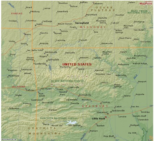 One of the most common statements I have heard is a tornado will jump or skip from one hilltop to the other, protecting the valley below. According to the Storm Predictions Center's website, by definition a tornado must be in contact with the ground, so one tornado will not jump from on hill to the next. A more in depth approach to this question would be the role terrain plays in storm motion and the inflow of the storm. In a modeling experiment, Balyee Balschmiter and Dr. Steve Weinbeck researched the impacts the deep valleys of northern Arkansas have on storm motion. The question was can valleys be used to explain changes in storm motion? They researched past storms movement in and around some of the larger valleys in the Boston Mountains. The conclusion was adjusting the data for channeling of winds through a valley did not change the storm's motion or speed. If a storm's overall motion and speed is not impacted by the terrain, what about the inflow of a storm? Can terrain weaken a storm's inflow? Though many researchers have tried to study the impact terrain has on a storm's inflow, the data seems to be inconclusive. Due to the low frequency of tornadoes and overall lower populations in mountainous regions, scientific observations of these storms are lacking. Though the data is inconclusive, there may be a trend of terrain playing a greater role in weak tornadoes than those that are stronger. A tornado only 5000 feet high may be greater impacted by a 1500 feet change of elevation than a tornado extending more than 15,000 feet. The Tornado Project website states the orographical effects may actually create an increase in strength: "Topography may have some influence, but protection is not one of them. Weak tornadoes may damage hilltops. But well-formed, mature tornadoes may actually stretch themselves into valleys and intensify. During this vortex stretching, the funnel diameter may shrink in diameter and the tornado will spin even more rapidly. This is hardly what one would call protection for buildings in a valley." With so little research and virtually no observations from within a mesocyclone moving over rugged terrain, the best way to examine the impact of terrain on tornadic development may be by looking at damage paths. Using Severe Plot software from the Storm Prediction Center, one can plot over 50 years of tornado data. If you stare at the map long enough you may start to recognize a minimum over the Ozark Plateau. This could be attributed to a few different reasons: There may very well be undocumented orographical reasons leading to a decrease in tornadic activity over the rugged terrain of the Ozark Plateau (including the Boston Mountains). The rugged terrain is not as suitable for viewing storms as you may find in Central Oklahoma, a shorter line of site, will lead to less tornado reporting. A less dense population will lead to fewer tornado sightings and fewer homes being damaged by storms that do traverse the area. Finally, culture and demographics may play a role, especially early in the observation period (1950s and1960s). Beverly Hillbillies aside, lack of technology may have led to no way of reporting sightings to local law enforcement and National Weather Service Forecast offices. 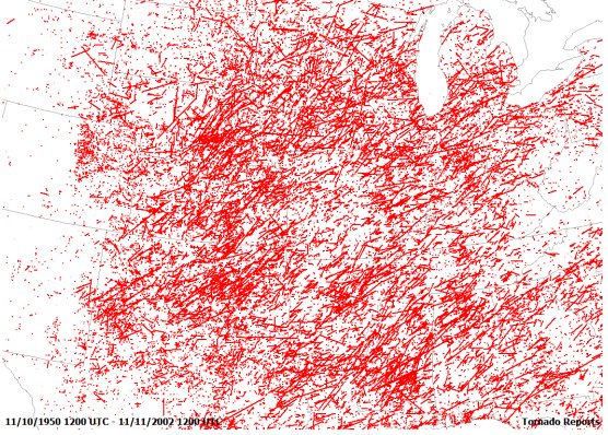 Taking a closer look at northern Arkansas leads to more inconclusive data. On the western side of the state, there seems to be a couple of areas that have had fewer reports of tornadoes. These areas correlate fairly well with the Ozark National Forest and the Ouachita National Forest. The low density of people in these National Forests may lead to fewer reports. There also seems to be a minimum on the eastern side of the state. This area lies in the flood plain of the Mississippi River, where one would believe topography would play virtually no role in the development of tornadoes. Even if the lower number of reported tornadoes over the Boston Mountains is due to orographical effects, the area is still not immune to deadly twisters. 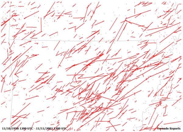 February 5, 2008, all the necessary ingredients for a severe weather outbreak came together. Plenty of wind shear, record warmth, and plume of moisture from the Gulf of Mexico all came together to produce 131 tornado reports according to the Storm Prediction Center. Many of those reports came from one tornado that spanned seven counties and traversed over 100 miles. This single storm killed 12 Arkansans. The storm started just south of the Arkansas River, near Centerville, crossed the Arkansas River (another myth busted) and moved northeast. This image from Google Earth gives a clear look at a portion of the path of the tornado and the topography. 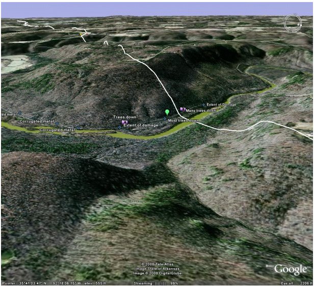 At its peak, the storm produced EF 4 damage in the town of Mountain View, AR, where it did extensive damage to the hospital. The damage path of this tornado ended in north central Arkansas near Highland, 123 miles from where it started. This would go down as the longest track tornado in the nearly 60 years of available records. There were eight other reported tornadoes in Arkansas that night, with most of them observed in the Boston Mountain region. When it comes to reliable data on the impact the Boston Mountains have on tornadoes, it is largely inconclusive. Whether there is decreased activity or not in the region, forecaster should not allow this to impact their warnings to the public. As has been proven multiple times, especially on February 5, 2008, the Boston Mountains are not immune to tornadic activity. The valleys, hidden some 1500 feet below the ridge line, offer no protection to communities from tornadic activity. Hopefully, the Super Tuesday outbreak will remind the residents of the Boston Mountains of their vulnerability and encourage them to be prepared. References: Balyee Balschmiter and Dr. Steve Weinbeck's presentation on storm motion: http://www.authorstream.com/Presentation/Lindon-17047-Balschmiter-Topographic -Influences-Storm-Motion-Background-Methodology-Speed-Results-Conclusion-Future- Refere-as-Science-Technology-ppt-powerpoint/ Storm Prediction Center: www.spc.noaa.gov The Tornado Project: http://www.tornadoproject.com/myths/myths.htm National Weather Service Little Rock http://www.srh.noaa.gov/lzk/html/svr0208.htm |