
Imagine you are traveling from Cleveland to Buffalo on a sunny November afternoon. An occasional patch of snow is noticed in the countryside. Cold winds blow briskly from the west, and the sky to the northwest starts to darken. Traveling a few miles further up the road, the sky becomes cloudy and flurries are encountered. Suddenly, the entire sky darkens on the horizon and the snow becomes heavier. Only a minute later, trillions of snowflakes are seen cascading to the ground at a rate of several inches per hour. Visibility decreases rapidly as snow intensifies. Hopes of getting to Buffalo end abruptly. What could have caused an incredulous change of weather within a stretch of a few miles? These so called "white outs" or "ground blizzards" occur in the Great Lakes region. This region spans from Wisconsin to New York and from the upper Midwest to southern Ontario in Canada. Each year lake-effect snows occur in areas bordering the Great Lakes. Major cities such as Erie, Syracuse, Cleveland, and Buffalo experience it. Through the understanding of atmospheric physics, it is now understood quite well. This section focuses on how lake-effect snow occurs, when and where it occurs, the result it brings, and how it can be predicted. Many of the heaviest snows in the United States have been the product of lake-effect snow. There are many reports of 2 or more feet of snow falling in a 24-hour period during several different lake-effect events. Lake-effect snow generally occurs from November to February. The snow is most intense in the late Fall and early Winter because the temperature gradient between the lake and the cold air is at a maximum in this time period. The temperature difference between the lake and the 850 millibar level is usually greater than 13° C for significant lake-effect snow to occur. Lake-effect snow can occur until the lake freezes. After this point, the temperature gradient is small and little moisture can be evaporated / sublimated. 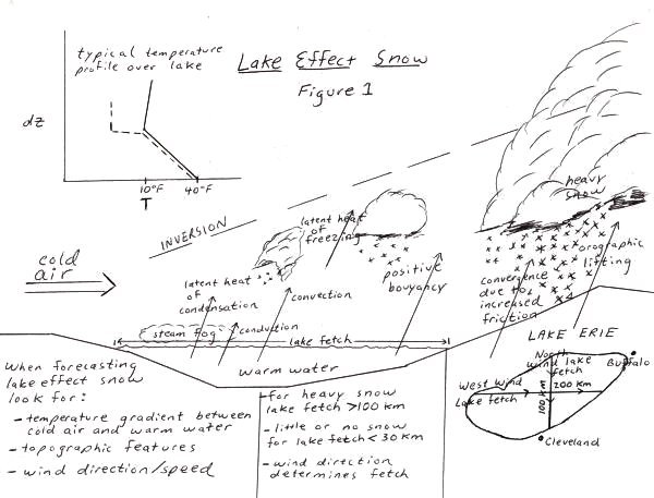 There are ingredients important to the lake-effect snow process. An overview is shown in Figure 1. First, the presence of a cold air mass overflowing the lake is needed. The polar air mass needs to be deep (at or above the 700 millibar level) and with small directional shear (change in wind direction less than 60° from surface to 700 millibars) for significant lake-effect snow to occur. This air mass originates from the continental polar regions of Canada. It filters over the lakes after a low-pressure system passes to the east. Cold air rushes in from the north and northwest with the counterclockwise winds. If the air mass is at least 13 ° C colder than the lake, heavy lake-effect snow can occur. Once the air overhead is colder than the water temperature, another important and smaller air mass develops just above the lake surface. Air above the surface of the lake is influenced by the lake. When the air is colder, the warmer water conducts and convects heat upward in accordance with the second law of thermodynamics. Because of conduction, the air just above the lake is about the same temperature as the lake, but decreases rapidly above this very thin layer. Above this layer, mixing of the cold and warm air occurs. This mixing decreases with height. The result is a temperature profile which decreases almost linearly. After moving sufficiently vertical above the lake, the warm water has no effect. The air above this point will either remain at a constant temperature or even could rise since the more dense, cold air descends. The temperature profile, after the cold air has moved over a significant fetch of warm lake water, is similar to the temperature profile on figure 1. This profile depends on the temperature of the air and lake water, the wind speed, and the thickness of the cold air mass. Higher winds steepen the temperature gradient since the modified air has less time to convect. The air near the lake surface and colder air aloft cause the atmosphere to be conditionally or absolutely unstable. The air becomes saturated at the surface since the lake is evaporating water. Because the colder air above the surface of the lake sustains a lower saturation vapor pressure than the warmer air at the surface, saturation and condensation into droplets, typically called steam fog, occurs. Convection results which leads to the development of snow crystals. Once this air mass, that has traveled over the open water, blows over land, the process of friction intensifies convection. While the air is flowing over the water it moves at a greater wind speed than over the land due to decreased frictional drag. This causes the air to pile up along the shore. Once piled up, it has no where to go but up. Also over land, the orographic effect increases uplift. Higher elevations increase cooling and condensation of water vapor in the air. Hilly areas exist on the eastern side of many of the Great Lakes, increasing lake-effect snow there. The wind speed determines how far inland and the horizontal spreading of lake-effect snow. With relatively light winds, the snow maximum will be closer to the shore. Strong winds tend to blow the snow further inland and produce a snow maximum which is more than 10 miles inland. The heaviest snows rarely occur right at shoreline. The winds blow the developing snow downwind from the lakeshore. Wind speed needs to be light enough across the lake in order for moisture convergence to occur. The moisture content of the air depends on the previous dewpoint of the air moving over the lake and the moisture acquired through evaporation over the lake. If winds are too strong in the PBL, over 50 miles per hour for example, enough moisture may not be able to evaporate to produce heavy lake effect snow. The best combination would be deep layer of arctic air moving between 10 and 40 miles per hour. Arctic air has some variation in dryness before it moves over the lake. Arctic air with an above average dewpoint will become saturated and produce more snow than arctic air that is extremely dry. Increasing the amounts of moisture in the air can occur from multi-lake interaction when polar air picks up moisture from an upwind lake before it moves over another downwind lake. Vertical soundings of heavy lake-effect snows reveal the wind direction is unidirectional with height. Directional shear decreases the moisture convergence out over the lake and causes the snow to spread over a larger area. Directional shear should be less than 30° from the surface to 850 millibars and less than 60° from surface to 700 millibars for heavy lake-effect snow. The depth of cold polar air must be of significant depth. Shallow arctic air limits the amount of convection that can take place. The depth of the arctic air needs to extend above the 850 millibar level and preferable above the 700 millibars level. The depth of the arctic air can be approximated by using a Skew-T diagram. The level of the inversion gives the depth of the continental polar air. Heavy lake-effect snow can not occur on any lake. The lake must be of large size (fetch greater than 100 kilometers) and exist at a latitude where cold temperatures are experienced. If the lake is not large enough, the volume of cold air will be much greater than the volume of modified air. This results in dispersion between the two air masses and a minute change in the temperature of the cold air. Steam fog may be seen over small lakes. If the lake is of a large size, latent heat release due to condensation and warming by conduction and turbulent mixing will create a large relatively warm air mass at the surface. This air mass becomes positively buoyant, and rises. Lake-effect snow can occur on all of the land surrounding the Great Lakes, but certain areas get much more than others. These areas are called snowbelts. There are three main reasons why they exist. First, cold wind from the polar areas usually travels toward the southeast. Since lake-effect snows can only occur on the downwind side of the lake, more snow falls on the south and east side than on the north and west side. Second, more snow falls on areas in which cold air travels over longer stretches of lake. The stretch of lake, air has to flow over, is called the fetch. A fetch of at least 100 km is needed for heavy lake-effect snow. Areas on the eastern and southern side of the lakes, that have long lake fetches, will receive large snowfall amounts. Lastly, topography is an important factor. Since hillier areas are mostly on the east side of the Great Lakes, the combination of cold winds usually from the northwest and hilly areas produce snowbelts in these areas. The longer the cold air travels over the lake, the more heat and moisture it can attain. Depending on the wind direction, fetch over the open water can be much less or much greater than 100 kilometers. Therefore, wind direction is of primary importance in determining which areas will receive the heaviest snowfall. The temperature gradient between the cold air and the warmer water is important. The warm air is more positively buoyant as the temperature gradient increases. From the second law of thermodynamics, conduction and turbulent mixing increases with an increasing temperature gradient. The questions decision tree found by [-clicking here-] has the 7 key ingredients for the production of very heavy lake-effect snow. A lake-effect snow sounding with a description of items favorable for lake-effect snow can be found by [-clicking here-] Below is how heavy lake-effect snow looks on radar. The west wind is producing bands of heavy snow down wind from the lakes Erie and Ontario. 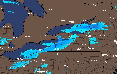 For current radar products visit: Intellicast |