
The PVA and NVA produced by the windflow through a vorticity maximum are well documented. The upstream region of a vort max experiences NVA while the downstream region experiences PVA. PVA is produced when parcels of air move from higher to lower values of vorticity. The PVA and NVA magnitude depends on the strength of the vort max, the spacing of the height contours and how the vorticity isopleths intersect the height contours. PVA and NVA are maximized due to a strong vort max placed within closely spaced height contours in which the vorticity isopleths are perpendicular to the height contours. The diagram below is an example of a vort max, the windflow through it, and the regions experiencing PVA and NVA. 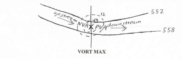 A vort min represents a region experiencing relatively low vorticity as compared to the surrounding region. A vort min is found in the region experiencing the greatest combination of negative shear and negative curvature vorticity. The curvature associated with a ridge will lead to negative vorticity. A clockwise shear pattern will also lead to negative vorticity. The letter "N" denotes a vort min on DIFAX. An example of a vorticity min is given in the diagram below. 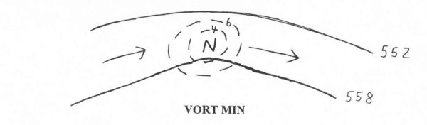 In operational meteorology, why is so much emphasis placed on the vort max and not a vort min? The answer will follow in the remainder of this article. First, lets examine the PVA and NVA pattern that is produced by a wind field through a vort min. As stated, PVA occurs when parcels of air move from higher to lower values of vorticity and NVA when parcels of air move from lower to higher values of vorticity. Since a vort min has the lowest values in the center (opposite from a vort max), the PVA and NVA are on different sides of a vort min as compared to a vort max. The PVA will be in the upstream region of the vort min and NVA will be in the downstream region. The diagram below shows the PVA and NVA produced by a flow through a vort min. 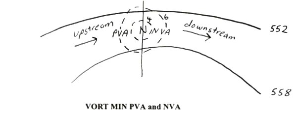 Since a vort min can generate PVA, why are vort min's rarely brought up in operational meteorology as being able to produce upper level divergence and lift? There are three primary reasons and they all relate to each other: (1) height contour spacing, (2) ridge curvature, and (3) vort min isopleth gradient. (1_explained) The generation of PVA and NVA rely on a wind flow through a vort max or vort min. The lighter the wind, the less the PVA and NVA. Ridges often have weak wind fields associated with them. The spacing of height contours is often far apart in the region a vort min occurs. A weak height contour gradient also leads to weaker negative shear and curvature vorticity. (2_explained) The curvature is usually more gradual in association with ridges than with troughs. This is due to the fact that high pressure tends to cover a larger surface area than low pressure and shortwaves. A more gradual curvature leads to less negative curvature vorticity, especially when winds are weaker. (3_explained) A weak wind field and weak curvature leads to weak negative shear and negative curvature vorticity which in turn leads to a weak vort min. Whereas a vort max often has a large central magnitude and a rapid change in vorticity isopleths moving upstream or downstream from the vort max, vort min's tend to have a weaker central magnitude and have a much more gradual vorticity isopleth gradient. Haby sez: A windflow through a vort min produces PVA in the upstream region and NVA in the downstream region, however, due to a lack of strong negative curvature, a lack of strong negative shear and weak winds flowing through the vort min, vort min's tend to be weak and subsequently produce weak PVA and NVA. |