
The one characteristic that all clouds have is the fact they contain saturated air. The water vapor content of this saturated air is largely a function of temperature and the rate of condensation. Thin clouds such as cirrus occur at high elevations where temperature are well below freezing. This cold air is unable to support much moisture. The sun is visible through cirrus clouds because of the low density of moisture in cirrus clouds. Clouds developing in a warm and humid environment are much more prone to block sunlight, especially if an updraft produces a large rate of condensation. Another characteristic of clouds is that they develop due to rising air. The elevation in the atmosphere from which the air rises determines cloud type. Rising surface parcels tend to produce cumulus. Isentropic lifting tends to produce Stratus clouds. The clouds isentropic lifting produces generally increase in elevation north of the warm front. Convective uplift produces cumulus type clouds while gradual uplift, such as isentropic lifting, produces Stratus clouds. The diagram below shows the most common clouds in association with a mid-latitude cyclone in which there is a "decent" amount of moisture to work with in the warm sector. If the warm sector is dry, cloud cover will not be as widespread. 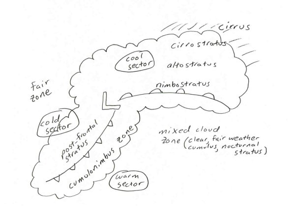 Cumulus clouds form in a vertically unstable environment. As surface temperatures increase, the likelihood for fair weather cumulus clouds increases, especially if dewpoints are high in the boundary layer. The time of the day when cumulus develops can be approximated by using the convective temperature on the Skew-T. The time of the day the temperature reaches the convective temperature determines when clouds form. If the convective temperature is larger than the predicted high for the day, fair weather cumulus are not likely. Maritime tropical air is more likely to have a lower convective temperature than continental air. Therefore, fair weather cumulus are more common in the warm sector of a mid-latitude cyclone or in association with maritime tropical air. Cloud cover will increase with the approach of a mid-latitude cyclone and associated fronts. Cloud cover in this situation increases from top-down. Cirrus clouds are the first to be seen, followed by altocumulus/ altostratus, and finally followed by the rain producing clouds of nimbostratus and cumulonimbus. Once the mid-latitude cyclone leaves, clear and cooler weather usually follows although cloud cover could still persist due to clouds wrapping around to the backside of low pressure, an upper level low, post-frontal Stratus, a second mid-latitude cyclone, or jet stream cloudiness. Cloud cover also depends on several mesoscale factors. Some of these include orographic uplift, the sea breeze, ocean/ lake induced clouds, PBL convergence and dryline convection. Personal experience is the best tool in predicting mesoscale cloud cover. One cloud forecasting problem is predicting when a layer of low Stratus or fog will "mix out". This can change a cloudy dull day into a nice sunny day in less than an hour. The sun plays a major role. Even on a cloudy day some of the sun's energy reaches the surface. If it didn't it would still look like night!. As this heat gradually builds, moisture evaporates from the fog and clouds. Once the sun breaks through to the surface, this allows a greater rate of the sun's energy to reach the surface which can cause a rapid dissipation of the low clouds. Thermal energy also increases instability in the PBL. This leads to increased wind speed. This more rapid mixing of air will also dissipate fog and low Stratus. If the surface soil and vegetation is saturated, this mixing out process will take longer. Evaporation (a cooling process) from the surface will offset the sun's energy which penetrates into the PBL. Therefore, the drier the soil the quicker the mixing out of low clouds. Of course other factors come into play. You will have to also look at synoptic scale processes such as fronts, thermal advection and vorticity advection to determine when cloud cover might break. An increase of surface cold/dry air advection will allow low cloud cover to dissipate more rapidly. Cloud information to keep in mind: *Clouds have higher bases if the PBL is dry. In general, the SW US and northern plains have mostly high cloud bases while the SE US tends to have lower cloud bases. *Stratus clouds form in a stable environment while cumulus form in an unstable environment. |