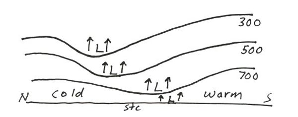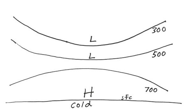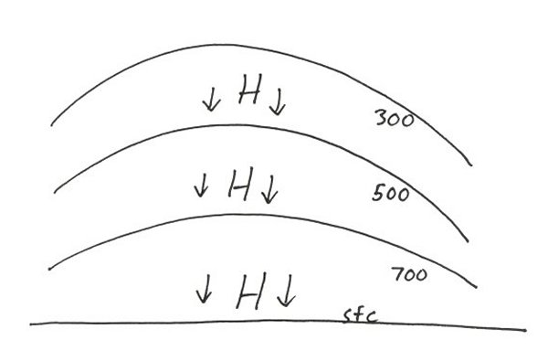
There are two classifications for low pressure systems and two for high pressure systems. Each of these pressure systems is sketched out in a vertical cross section and described. COLD CORE LOW  *Rising air in all levels of atmosphere *Cover a relatively small synoptic scale area compared to high pressure systems. Their path can heavily influence precipitation totals *Developed cold core lows tilt to the northwest with height *Coldest temperatures are at center of low *Air is cooled by adiabatic expansion and evaporational cooling of rain and/or snow *Upper low can displace from lower level low, models have more difficulty handling upper level lows as compared to low level lows due to poorer model resolution in the upper levels *Most mid-latitude cyclones are cold-core lows *They cause widespread precipitation *They are deep cored. Developed cold core lows will show at each mandatory level. They will have closed height contours in the low levels and shows as a synoptic scale trough in the upper levels *Will develop into significant storm systems with a large release of latent heat *Initially develop due to jet streaks, synoptic thermal gradient zones or vorticity spin-up WARM CORE LOW TYPE 1: Thermal low  *Thermal lows are shallow and most intense at surface *Develop due to strong surface heating. Hot air due to intense thermal build-up results in positive buoyancy at the surface *Mid and upper levels are stable *Most common in SW US during Summer *Develop over land (especially dry land with little vegetation) *Due to dryness of PBL, precipitation is not common with the exception of an isolated afternoon thunderstorm TYPE 2: Tropical cyclone  *Deeper than thermal low, although they do weaken with height in upper levels *Subsidence (sinking air) in center causes compressional warming *Air rises rapidly around edges of eye (eye-wall) *Develop over water *Warm core low is strongest when vertically stacked. Significant wind shear will weaken warm core low. This is the opposite situation of a cold core low; strong cold core lows tilt with height. COLD CORE HIGH  *Can be shallow or deep: most intense at the surface (due to cold/dense air) and weaken with height if away from source region. The upper levels will show a deep trough if the polar air mass moves into mid-latitudes. Cold core highs are deep near their source regions *Precipitation generally lacking near cold core high center *Covers a large spatial area *Produces synoptic scale surface subsidence *Develop over high latitude land WARM CORE HIGH  *Deep highs: extend through large depth of atmosphere *Precipitation is lacking or is in the form of convective daytime heating storms *Temperatures warm to hot at surface *Although warm air is relatively less dense, the sinking through a large depth of the atmosphere produces high pressure. *Covers a large spatial area |