
1. What is CINH? CINH (Convective Inhibition in units of Joules per kilogram) is anti-CAPE (negative CAPE) in the lower troposphere. This is the region where a parcel of air if raised from the lower PBL would sink back down again. Another term for CINH is a capping layer. The capping layer must be broken before lower PBL based lifting is able to move into the +CAPE region of a sounding and develop into deep convection. 2. How is CINH determined? CINH is the area of the sounding between the surface and to the level at which +CAPE begins. In the CINH region the parcel will be cooler than the surrounding environment-- thus this is a stable layer. The sounding at the bottom of this page shows a CINH value 37 J/kg. This is a weak cap, especially considering daytime heating has not even begun. Convection will likely start early this day. 3. Operational significance of CAPE:
CINH will be reduced by: 1) daytime heating, 2) synoptic upward forcing, 3) low level convergence, 4) low level warm air advection (especially if accompanied by higher dewpoints). CINH is most likely to be small in the late afternoon since daytime heating plays a crucial role in reducing CINH. 4. Pitfalls: a. Index is only relevant to lower PBL based convection. Index is usually only relevant in a barotropic environment or in the warm sector of a mid-latitude cyclone. b. Index is only relevant when there is a cap to be broken. If no +CAPE exists above PBL, then the CINH value is meaningless. c. Keep in mind the factors that day that will either enhance or reduce the capping inversion. See forecast soundings. 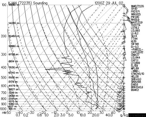 |