
1. What is MPL? The MPL (Maximum Parcel Level) is the maximum height a thunderstorm will build in the atmosphere using pure buoyancy theory. The MPL is higher than the EL (Equilibrium Level) since updraft momentum carries the updraft higher as the updraft decelerates. 2. How is MPL determined? First, the amount of CAPE is determined between the Level of Free Convection and the Equilibrium Level. Once this area of CAPE is found, an equal area of negative CAPE is filled in above the EL. The top of this area of negative CAPE is the MPL. The sounding below has an EL of 159 mb and a MPL of 89 mb. The area of negative CAPE (parcel colder than environment) between 159 and 89 mb is equal to the amount of positive CAPE between 809 mb and 159 mb. The negative CAPE is in a more compressed vertical distance due to the intense stability encountered as the tropopause is entered. 3. Operational significance of MPL: UPDRAFT: A MPL much higher than that EL indicates an intense updraft. 4. Pitfalls: a. Both the CAPE and negative CAPE calculated from pure buoyancy theory do not take into consideration the mass of water (in all three phases) in the air. Mass reduces CAPE while enhancing negative CAPE. 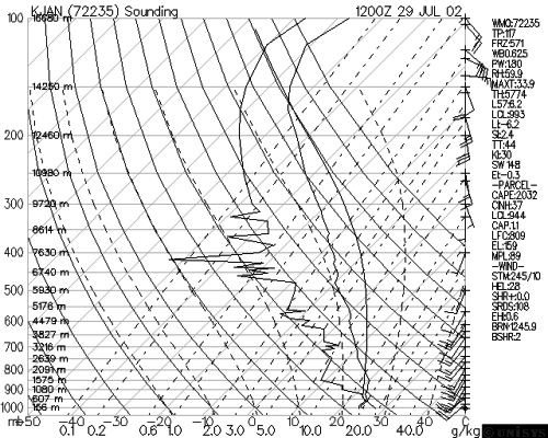 |