
1. What is BRN? BRN (Bulk Richardson Number) is an index that assesses the balance between instability (CAPE) and wind shear (speed and directional shear with height) in a thunderstorm environment. 2. How is BRN determined? The basic formula is CAPE / SHEAR. CAPE is the amount of pure instability present relative to a rising surface parcel. SHEAR is a mean wind vector between the surface to 500 m above surface average wind speed and the surface to 6 kilometer average wind speed. BRN= CAPE / (0.5*(shear differential)^2) The sounding at the bottom has a BRN of 65.4. The extreme CAPE value leads to the high BRN. 3. Operational significance of BRN:
CAPE determines the updraft strength while the SHEAR determines storm character (supercell, MCS, pulse). Multi-cell storms (MCS) are favored in cases where good speed SHEAR is present but low level directional shear is weak. Pulse storms are favorable in cases with high CAPE and low shear. Supercells are favored when CAPE and SHEAR are in balance and both are significant. 4. Pitfalls: a. Do not use index when CAPE and SHEAR are both small. CAPE should be at least 500 J/kg and SHEAR should be at least 10 m/s. b. Several combinations of CAPE and SHEAR can produce the same BRN. Always inspect the actual amount of instability and wind shear when assessing the relevance of the BRN value. The table in #3 is only a likeliness!- not a guarantee. c. Index gives no moisture, cap, directional wind shear, jet stream wind or lift information. Assess these along with the BRN. 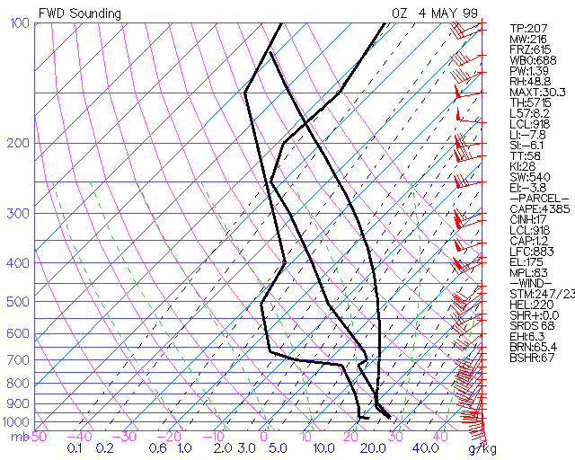 |