
SEVERE STORM STRUCTURE:
FORWARD FLANK AND REAR FLANK DOWN DRAFT
| |||||||||||||||||||||||||||||||||||||||||||||||||||||||||||||||||||||||||||||||||||||||||||||||||||||||||||||||||||||||||||||||||||||||||||||||||||||||||||||||||||||||||||||||||||||||||||||||||||||||||||||||||||||||||||||||||||||||||||||||||||||||||||||||||||||||||||||||||||||||||||||||||||||||||||||||||||||||||||||||||||||||||||||||||||||||||||||||||||||||||||||||||||||||||||||||||||||||||||||||||||||||||||||||||||||||||||||||||||||||||||||||||||||||||||||||||||||||||||||||||||||||||||||||||||||||||||||||||||||||||||||||||||||||||||||||||||||||||||||||||||||||||||||||||||||||||||||||||||||||||||||||||||||||||||||||||||||||||||||||||||||||||
METEOROLOGIST JEFF HABY
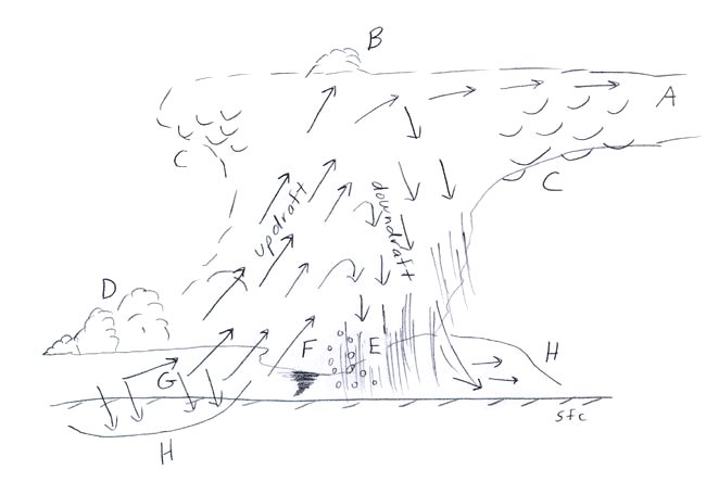
The forward flank downdraft is the
outflow from the rain-cooled air of the storm's downdraft. The rear flank downdraft is air from aloft that is
transported down to the surface from colliding with the storm. The rear flank downdraft air tends to be
dry and warm since the air warms by adiabatic compression as it sinks to the surface. Adiabatically
warmed air will also decrease in
relative humidity if no precipitation falls into the air. The rear flank
downdraft tends to be warmer than the
forward flank downdraft also since rain and
evaporative cooling is not as common in the rear flank.
Shear is
enhanced along these flanking downdraft boundaries and
the shear can be magnified along where the two flanks merge. The right balance of shear and
instability release
can lead to
tornadogenesis.
The diagram below shows the forward and rear flank downdrafts at "H". The rear flank downdraft is on the
left side and the forward flank is on the right side of the diagram.
|
|
|