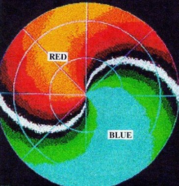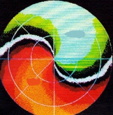
Please read the following Haby Hint: http://www.theweatherprediction.com/habyhints/48/ On radial velocity, red and yellow colors represent motion away from the radar and greens and blues represent motion toward the radar. As the radar beam moves away from the radar site it will usually increase in altitude as range from the radar increases. Thus, locations near the radar site will be sampled close to the surface while locations at the outer range of the radar will be sampled at a much higher elevation. Radial velocity colors will only be shown where there is hydrometeors or other particles in the troposphere for the radar beam to scatter off. It is precipitation and thunderstorm areas where the best returns will occur. The images below are idealized since they show colors across the entire radar sampling area. This is reality would generally only occur if precipitation was occurring across the entire radar sampling region. Look at the image below depicting an idealized veering wind. The winds near the radar are from the east. We know this because of the yellow colors immediately to the west of the radar (motion away) and the blue colors immediately to the east of the radar (motion toward). The white curving line on the image is the zero radial motion. Within the area in white motion is neither toward or away from the radar but is rather motion that is remaining equidistant from the radar site at that point in space. A key point to remember is that the winds will flow perpendicular to this white zero radial velocity line. At the middle ranges from the radar site the winds are from the southeast and south. We know this is the wind direction here because winds cross the white radial velocity perpendicularly and motion is from the blue and green colors toward the yellow and red colors. At the outer ranges of the radar the wind is from the southwest. The outer ranges of the radar will be the highest in elevation sampled. Thus, going from the surface to aloft the winds shift from easterly to southeasterly to southerly to southwesterly. This is a veering wind since the wind is turning clockwise with height. A veering wind is associated with warm air advection since low level winds from a southerly direction will generally transport in warmer air. Remember the initials CVW, where these letters stand for Clockwise, Veering, Warm Air Advection. A veering pattern on radial velocity will have an S-shaped pattern. See the veering wind image below and notice the S-shaped signature made by the white zero radial velocity radial. A student posted a message for the way to remember that an S-shaped pattern is associated with warm air advection is to remember that Superman has a warm heart. Superman has an S on the shirt. The second image below shows a backing wind. The wind is from the east at the surface, then gradually shifts to the northeast and then to the north at the outer range. A backing wind will shift counterclockwise with height. Remember the initials CCBC, where these letters stand for Counter-Clockwise, Backing, Cold Air Advection. A backing wind pattern will have a backward-S shaped radial velocity pattern. VEERING WIND WITH HEIGHT  BACKING WIND WITH HEIGHT 
|