
| CREATION OF GREAT PLAINS THUNDERSTORM CAP AND EML
| |||||||||||||||||||||||||||||||||||||||||||||||||||||||||||||||||||||||||||||||||||||||||||||||||||||||||||||||||||||||||||||||||||||||||||||||||||||||||||||||||||||||||||||||||||||||||||||||||||||||||||||||||||||||||||||||||||||||||||||||||||||||||||||||||||||||||||||||||||||||||||||||||||||||||||||||||||||||||||||||||||||||||||||||||||||||||||||||||||||||||||||||||||||||||||||||||||||||||||||||||||||||||||||||||||||||||||||||||||||||||||||||||||||||||||||||||||||||||||||||||||||||||||||||||||||||||||||||||||||||||||||||||||||||||||||||||||||||||||||||||||||||||||||||||||||||||||||||||||||||||||||||||||||||||||||||||||||||||||||||||||||||||
METEOROLOGIST JEFF HABY
A cap is a vertical region of stable air that prevents convection from penetrating through this vertical layer. As long as this
layer prevents convection, the cap is in place. This cap or capping inversion is at the base of the Elevated Mixed Layer (EML). This
capping layer of stable air can act to prevent thunderstorm activity. This layer can also prevent the premature release of weak
convection; Convection finally occurs when strong convective elements are able to penetrate the cap. These strong convective
elements can lead to intense storms. Thus, the cap can act to both decrease (by preventing any thunderstorm activity) or increase
thunderstorm severity.
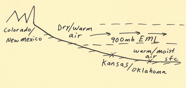
The diagram below gives the basic setup for how an elevated mixed layer (EML) cap is formed. The surface boundary of where the warm/moist
air meets the warm/dry air is the dryline boundary. Dry and warm air from higher elevations is advected generally toward the east by
a developing low pressure system. As the air is advected toward the east, it generally maintains the altitude it had at the higher
elevations. As the air moves east, it flows over the top of warm and moist air. The depth of the warm and moist air generally
increases when moving further east toward lower elevations. The capping inversion is a stable layer that traps the moist and warm air
beneath it. However, with enough daytime surface heating and lifting mechanisms (i.e. surface front, warm air advection,
upper level divergence) the stable layer can be penetrated by surface based convective elements and this can lead to
violent storms. The strength of the cap can be the difference between no storms (a bust if severe weather was likely) and
very intense thunderstorms (release of huge amounts of convective instability). Forecasters monitor conditions closely using
vertical soundings, model output and surface observations.
|
|
|