
| HABYTIME MINI LECTURE 5: THE WARM FRONT
| |||||||||||||||||||||||||||||||||||||||||||||||||||||||||||||||||||||||||||||||||||||||||||||||||||||||||||||||||||||||||||||||||||||||||||||||||||||||||||||||||||||||||||||||||||||||||||||||||||||||||||||||||||||||||||||||||||||||||||||||||||||||||||||||||||||||||||||||||||||||||||||||||||||||||||||||||||||||||||||||||||||||||||||||||||||||||||||||||||||||||||||||||||||||||||||||||||||||||||||||||||||||||||||||||||||||||||||||||||||||||||||||||||||||||||||||||||||||||||||||||||||||||||||||||||||||||||||||||||||||||||||||||||||||||||||||||||||||||||||||||||||||||||||||||||||||||||||||||||||||||||||||||||||||||||||||||||||||||||||||||||||||||
METEOROLOGIST JEFF HABY
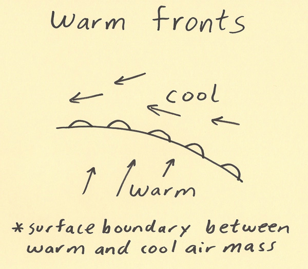
A warm front is a surface boundary separating warm and cool air masses in which the warm air is replacing cooler air. A warm front
is often associated with a low pressure system and occurs where the flow around a mid-latitude cyclone is forcing air from lower
toward higher latitudes. The sketch below is of a warm front and the common wind flow in the vicinity of the front. The semicircles
point in the direction the front is moving.
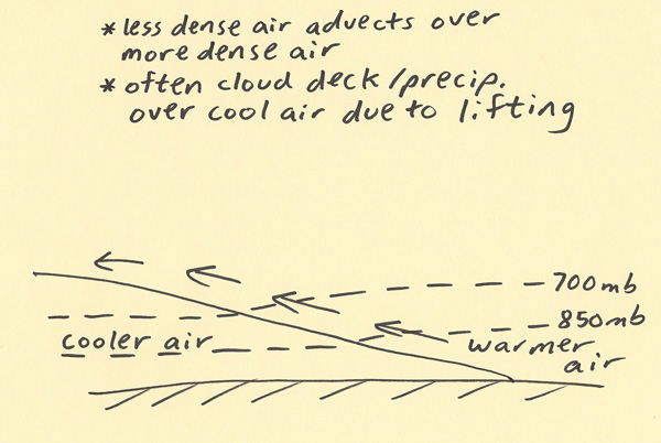
Near the warm front boundary, the cool air preceding the surface warm front is shallow while the cooler air gets deeper with increasing
distance from the surface warm front. The warm front moves by the warm air mixing out the very shallow cool air at the surface
warm front boundary. Faster wind helps this process occur more quickly thus strong winds can help move the warm front
boundary quicker. It is a slower process for warm air to erode cooler air than it takes for cold air to undercut warm air,
thus warm fronts tend to move slower than cold fronts. Over time, the cold front will overtake the warm front due to this
process (producing an occluded front). Since warm air is less dense than cooler air, warm air easily lifts over the top of
the slope of cooler air (isentropic lifting). Thus, clouds and precipitation are common in the region preceding the surface
warm front passage where the cool air is located. The sketch below shows the vertical cross section of a warm front and the
warmer air moving up the slope of the cooler air.
|
|
|