
Sleet is also called ice pellets. Sleet can be thought of as “frozen raindrops” but the process of the freezing of these raindrops requires a unique situation. Sleet is a form of winter precipitation that reaches the ground as typically small balls of ice. The process of the formation of sleet is totally different then the process that forms hail thus the two should not be confused. The formation of sleet first begins with the formation of snow aloft. This snow then falls through a layer of air aloft that is above freezing. This above freezing layer is also deep enough to almost completely melt the snow. What is left is rain but with a little ice left in the raindrops. This leftover ice that has not melted yet is critical because it acts as a freezing nucleus when the raindrops fall through a below freezing layer. Before reaching the ground, the raindrops with some ice still remaining fall through a sub-freezing layer which causes the liquid water to freeze into ice within each raindrop. The frozen ice pellets reach the surface and have a characteristic bounce when they hit the surface and they have a distinct sound when hitting the surface. What if the snow falling aloft completely melts (no ice nuclei left) and then the raindrops fall through a subfreezing layer before reaching the surface? That will be the subject of the next mini lecture on freezing rain. Below is a summary of the sleet formation process and then we will look at a typical tropospheric profile that produces sleet  Below is an illustration of the process of sleet formation. The vertical dashed line through the center is the freezing point of 0 C. To the right of this line the temperature profile is above freezing and to the left of this line the temperature profile is below freezing. The precipitation starts as snow aloft in the subfreezing layer. The snow then falls into an above freezing layer and the snow mostly melts into rain but there is still a little ice left in the raindrops. Before reaching the ground, the raindrops then fall through a subfreezing layer and the raindrops with embedded ice nuclei freeze solid into little balls of ice. A situation called “wet sleet” can occur when at the surface there is an additional above freezing layer just before the sleet reaches the ground. This causes the sleet to partially melt before it reaches the ground. In this case there can be sleet mixed with rain. Also, it could be the case that the subfreezing layer near the surface is shallow enough that the raindrops do not have enough time to completely freeze solid before they hit the ground. This can also produce a wet sleet of rain and sleet together. There is a very fine line in the vertical temperature profile that can contribute to each winter precipitation type. The temperature profile can change just by a little and it will have a significant impact on the winter precipitation type. Thus, it is not uncommon to experience snow, sleet, cold rain and freezing rain all within a short time period and in some cases several winter precipitation types all at the same time! 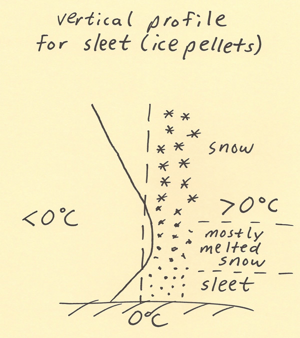 |