
The polar jet stream is an upper level ribbon of wind of troughs and ridges and goes around the Earth that generally separates the polar from the mid-latitude air masses. The polar jet stream shifts in the average position and altitude that it occurs when comparing winter to summer. First, the winter position will be examined. The polar jet stream typically can be found between 500 and 100 mb. There is a vertical range of about 250 mb of where the jet stream winds are found. In the winter season, the core of the polar jet stream (pressure level with strongest wind speeds) can be found near 300 mb. The wind speeds associated with the polar jet stream tend to be stronger in winter as compared to summer. This occurs because there is a greater contrast in temperature between the polar and mid-latitude regions. The 24-hour darkness results in the polar regions getting very cold in winter. Not only are the winds stronger in winter, but the position of the polar jet stream shifts closer toward the equator and thus the polar jet stream influences more of the mid-latitude regions in winter. Since the winds tend to be stronger and more amplified in winter, the jet stream dynamics (jet streak divergence, PVA, troughing) tends to be stronger also. This can help lead to big shifts in weather over the course of a few days in the middle latitudes in winter. 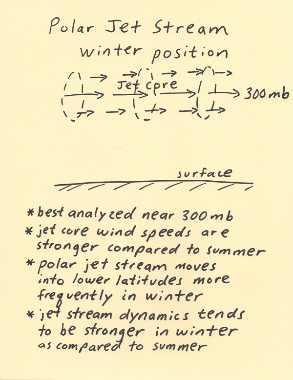 Next, the polar jet stream position in summer will be discussed. The position of the polar jet stream is located near 200 mb in summer (as compared to near 300 mb in winter). The wind speeds associated with the polar jet stream tend to be weaker in summer as compared to winter. This occurs because there is a weaker contrast in temperature between the polar and mid-latitude regions. The 24-hour sunlight results in the polar regions getting much warmer than they were in winter. Not only are the winds weaker in winter, but the position of the polar jet stream shifts closer to the pole and thus the polar jet stream influences less of the mid-latitude regions in summer. Since the winds tend to be weaker and less amplified in summer, the jet stream dynamics (jet streak divergence, PVA, troughing) tends to be weaker also. 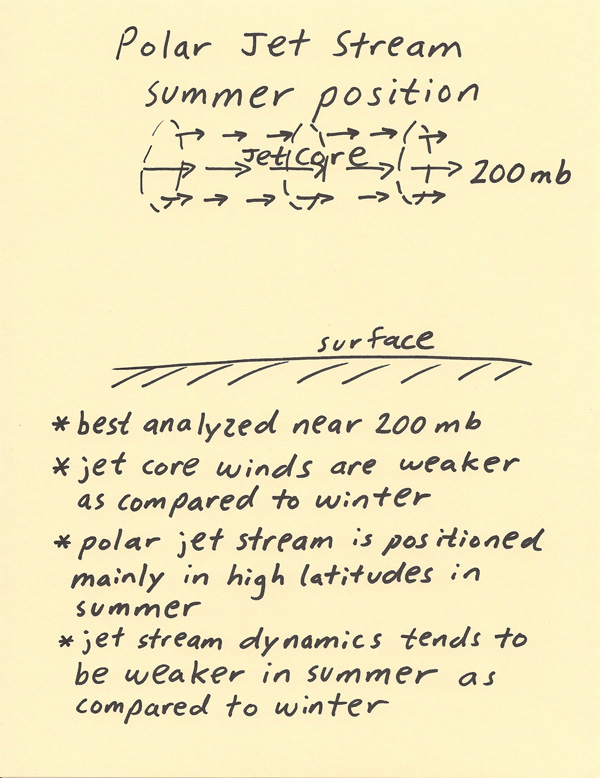 The final point we will look at in this mini lecture is why the core of the jet stream shifts from an average position of about 300 mb in winter to a position of about 200 mb in summer. In the winter, a very cold air mass persists over the polar regions. The 24-darkness leads to extremely cold temperatures. This cold air is very dense and dense air does not occupy as much volume and therefore is not vertically as deep. There is an extreme contrast in air mass temperature in winter between the cold polar air and much warmer mid-latitude air. The temperature gradient is what produces the winds of the jet stream. Since the cold air mass is shallower in winter (due to being more dense), not as much vertical depth is required to get to the upper troposphere. Thus, the jet stream winds can develop at a lower altitude and pressure level. The core of the polar jet stream winds are still in the upper troposphere in winter but just not quite as high up as compared to summer. In the summer, the polar areas are warmed by 24-hour sunlight. The contrast between the polar temperatures and mid-latitude temperatures is much less in summer. Thus, the temperature gradient between the poles and mid-latitudes is weaker resulting in a generally weaker jet stream. The air in the polar regions is much warmer than winter (and thus less dense) and thus the vertical depth of the troposphere is higher in summer. This results in the position of the core of jet stream winds being closer to 200 mb in summer. The diagram below shows the winter vs. summer contrast in jet stream height. 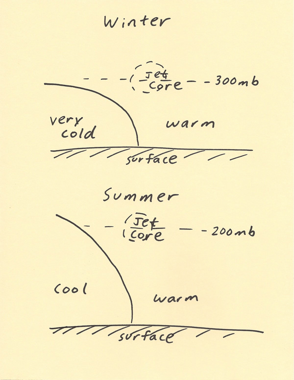 |