
The cold front typically moves faster than the warm front. Because of this, the cold front overtakes the warm front over time. This can be analyzed when monitoring the day by day progression of a middle latitude cyclone. The front that is produced when the cold front overtakes the warm front is called the occluded front. The occluded front situation is very interesting to analyze when it comes to differential advection and the analysis of the air masses that make up the occluded front environment. In an occluded front situation, the cold front is overtaking the two air masses that make up the warm front environment. In the warm front, warm air is advecting over cool air. When the occluded front overtakes the warm front environment, the occluded front will lift up both of these air masses. The top diagram below shows the occluded front, cold front and warm front. The occluded front is the front closest to the low pressure center. As the occluded front matures, it will result in the cold and warm fronts being further away from the low center. Eventually the cold and warm fronts will lose their identity once they are too far from the low center and what will be left is a weakening low center along with an occluded front. The bottom diagram shows a southwest to northeast cross section of an occluded front and the three air masses present in the occluded front environment. Where the cold (1) and cool (2) air masses meet at the Earth’s surface is the position of the surface occluded front. The region of cool air (2) is the cool air that is out ahead of the warm front. The cold air (1) is the cold front that has wrapped around the low to the point that it is lifting the warm front. The region of air at (3) is the air that was once the warm air behind the warm front, that then lifted over the warm front, which was then further lifted by the occluded front. This air (3) has been lifted so much that it is no longer really warm but in the process of lifting there can be significant precipitation produced from this air, especially if it originated from a moisture source. The air at (3) has been labeled “air that originally lifted over warm front” to explain the process that this air went through to get where it is at. When analyzing from a differential advection perspective, there are three air masses in this example that are interacting in the occluded front environment. Each of these air masses will have different temperature, moisture and wind direction properties. Around the occluded front, one of these air masses (3) is no longer in contact with the Earth’s surface. With the significant lifting that the air at (3) experiences, it is common to have precipitation along and out ahead of the occluded front boundary. 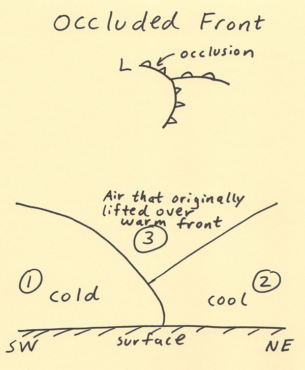 |