
Conditional instability is an important topic in operational meteorology. A good working knowledge of conditional instability comes in handy when using the Skew-T Log-P diagram. There are two adiabatic lapse rates which are the dry adiabatic lapse rate and the wet adiabatic lapse rate. The dry adiabatic lapse rate is a decrease of 10 Celsius for each kilometer that the air rises. The wet adiabatic lapse rate depends on how much latent heat by condensation is released to the air in a rising saturated parcel of air. Dry adiabatic warming cools the air while latent heat release warms the air. In a rising saturated parcel, the dry adiabatic lapse rate has a greater rate of cooling then the rate of warming due to condensation, thus a rising saturated parcel still cools but by a value that is less than 10 Celsius per kilometer. The typical wet adiabatic lapse rate in a thunderstorm environment is around 5 Celsius per kilometer. The wet adiabatic lapse rate ranges from about 4 C/km in very warm saturated air to near the dry adiabatic lapse rate of 10 C/km in very dry and cold air. The rest of this writing will use the 5 C/km value for easy comparative purposes. The diagram below shows two parcels of air. The first parcel is saturated and rises at the wet adiabatic lapse rate of 5 C/km while the second parcel is unsaturated and rises at the dry adiabatic lapse rate of 10 C/km. Notice the magnification of temperature difference between each parcel as it rises in each 1 km increment. After 1 km, the temperature difference is 5 units. After 2 km, the temperature difference is 10 units. After 3 km, the temperature difference is 15 units. Thus an important point to make is that the wet parcel stays much warmer than the dry parcel especially the higher it goes. The significance of this and how it relates to conditional instability will be explained next. 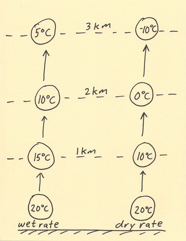 The diagram below shows a temperature profile as it would look on a Skew-T. There are two parcels of air at the surface. One parcel is dry while the other parcel is wet. The dry parcel (left side of temperature profile) decreases in temperature rapidly with height on a Skew-T. The moist parcel (right side of temperature profile) decreases in temperature slowly with height on a Skew-T. Notice the saturated parcel stays right of the temperature profile. Being to the right of the temperature profile means the parcel is warmer than the temperature profile. This leads to the parcel rising on its own due to positive buoyancy. This parcel trajectory will produce CAPE. Notice the dry parcel stays left of the temperature profile. Being to the left of the temperature profile means the parcel is colder than the temperature profile. This leads to the parcel being stable. This parcel trajectory will not produce CAPE. A conditionally unstable situation is one in which a parcel will be unstable with respect to the temperature sounding if it lifts at the wet adiabatic lapse rate but will be stable with respect to the temperature sounding if it lifts at the dry adiabatic lapse rate. Thus, low level moisture is a critical component to thunderstorm development. Higher amounts of low level moisture will lead to stronger CAPE and thus stronger convective uplift. Air that is too dry in the low levels will not be able to develop into surface based convective thunderstorms or the surface based storms will be weaker. 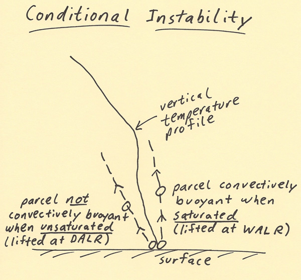 |