
CAPE stands for Convective Available Potential Energy. It is an index that gives an indication of how powerful an updraft will be in a thunderstorm or convective situation. The higher the CAPE then the more powerful the updraft will be. This writing addresses slim CAPE and how slim CAPE can transform into monster CAPE. CAPE tends to be a smaller value in the morning since a critical component to producing high CAPE is a high boundary layer temperature. At night, the boundary layer cools which will decrease CAPE. CAPE often does not exist at all in the cool half of the year since the surface temperature is too cool. CAPE may not be present if the boundary layer is dry. A high surface dewpoint and a high surface temperature will help produce CAPE. When no CAPE is present or only a small amount is present then the CAPE value will be less than 100. Even days with severe weather threats will often see a dramatic transition of CAPE throughout the day. Slim CAPE can transform into CAPE capable of producing updrafts that can lead to severe thunderstorms. In a slim CAPE situation (shown below), the parcel profile will only produce a small amount of area on the Skew-T in which the parcel is warmer than the environmental temperature (shaded area). We can imagine some changes to the parcel sounding and the temperature sounding that will produce a higher CAPE. In the diagram below, imagine the parcel sounding being more to the right of the temperature profile so that a larger shaded area is produced to the right of the temperature profile. This can be done in several ways: 1. Warm the surface temperature- This will shift the parcel sounding more to the right. 2. Increase boundary layer dewpoint- This can decrease the amount of dry adiabatic lifting needed to reach the Lifted Condensation Level. This helps the parcel to be warmer than it otherwise would be. It will also give the parcel more moisture that can be used to release latent heat. This will shift the parcel sounding more to the right. 3. Cool the Middle and Upper troposphere- This can be accomplished through lifting mechanisms. In looking at the diagram below, if the temperature profile would be shifted to the left in the middle and upper portions of the diagram then this will produce a larger shaded area where the parcel sounding in warmer than the temperature profile. A larger shaded area is a larger CAPE. These three processes above can turn a weak morning CAPE into a high afternoon CAPE. This can be accomplished due to solar heating of the ground, boundary layer moisture advection from a moisture source and lifting mechanisms approaching such as PVA, a front, jet streak divergence, and low level warm air advection. Thus, a forecaster has to be mindful of the processes that can turn a weak CAPE into a strong CAPE as the day progresses. 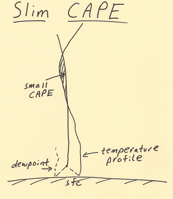 |