
METEOROLOGIST JEFF HABY
The flow over elevated terrain can set up turbulence that produces unique cloud formations and airflow patterns that can be dangerous to aircraft. As
air flows over the mountain or mountain range it is forced upwards. If the air is unstable, the air will continue to rise and can produce rain or
storms in the vicinity of the mountain. Mountain wave turbulence is typically set off when the air is stable. This is because as the air is forced
lifted, after it goes over the mountain it will want to return to its original elevation. As the air moves downstream it will overshoot and
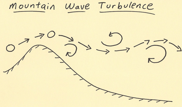
undershoot this equilibrium point as it continues to move downstream. This produces a wave pattern to the airflow. What is dangerous to
aircraft is the turbulent eddies that can be set off as air moves through a curved pattern at the base and top of each wave. This produces
dramatically different wind directions over a short distance. An aircraft trying to adjust to a certain wind speed and direction will
suddenly be impacted by a totally different wind speed and direction. This can produce severe turbulence as the aircraft goes across
the eddy. Pilots have to have aware of these situations and adjust the flight pattern when this type of weather pattern has the potential
to impact an aircraft. This turbulence can occur even with no clouds present. This is called clear air turbulence. This makes it even more
dangerous to aircraft since there are no clouds to give a signal of the turbulence that is present. Below is a diagram showing mountain wave
turbulence and the eddies that can be generated as the air moves downstream.
|
|
|