
HABYTIME MINI LECTURE 78:
OPTIMUM SNOWFALL REGION
| |||||||||||||||||||||||||||||||||||||||||||||||||||||||||||||||||||||||||||||||||||||||||||||||||||||||||||||||||||||||||||||||||||||||||||||||||||||||||||||||||||||||||||||||||||||||||||||||||||||||||||||||||||||||||||||||||||||||||||||||||||||||||||||||||||||||||||||||||||||||||||||||||||||||||||||||||||||||||||||||||||||||||||||||||||||||||||||||||||||||||||||||||||||||||||||||||||||||||||||||||||||||||||||||||||||||||||||||||||||||||||||||||||||||||||||||||||||||||||||||||||||||||||||||||||||||||||||||||||||||||||||||||||||||||||||||||||||||||||||||||||||||||||||||||||||||||||||||||||||||||||||||||||||||||||||||||||||||||||||||||||||||||
METEOROLOGIST JEFF HABY
This writing discusses where the heaviest snow typically falls in association with a mid-latitude cyclone. The two charts that will be discussed
to use and what to look for will be the 850-mb analysis chart and the 500-mb analysis chart. First, the 850-mb chart will be discussed.
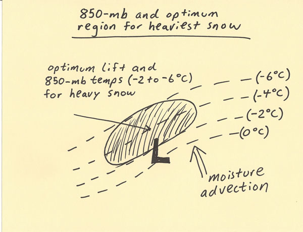
In the 850-mb pressure surface depiction below, the position of the center of the low pressure system and isotherms are shown. The heaviest
snow tends to fall just to the northwest of the track that the low pressure is on and where the temperatures ranges from -2 C to -6 C
at 850-mb. In this region is the greatest combination of lift and a temperature profile that will support snow. This will tend to produce
the heaviest snow is a band-like feature as the low pressure system propagates. It helps to have a moisture source the low pressure can
tap into. In the diagram there is moisture advection into the low from the southeast. This moisture wraps up and around the low to supply
the fuel for the heavy snow on the northwest side of the low pressure system. Next, the 500-mb chart and where the heaviest snow tends
to occur will be discussed.
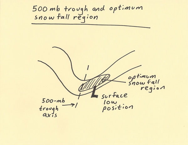
The depiction below is the 500-mb trough. Drawn on the diagram is where the position of the center of the surface low would be. Just like
on the 850-mb chart, it is showing the optimum heavy snow region to the northwest of the low. Notice that when looking at the 500-mb trough,
the optimum snow is occurring on the right side of the trough axis. This is the same region that will experience upper level divergence
from positive vorticity advection and potentially jet streak divergence also. Thus, the region of optimum heavy snow often occurs at
the position it does with a mid-latitude cyclone due to the numerous lifting mechanisms that can overlap in this region, a temperature
profile that can support snow, and a location where moisture advected into the low pressure system is forced upwards.
Strong lifting + abundant moisture + optimum temperature profile = heavy snow.
|
|
|