
| WX MODEL 20: Temp Gradient and Jet Stream
| |||||||||||||||||||||||||||||||||||||||||||||||||||||||||||||||||||||||||||||||||||||||||||||||||||||||||||||||||||||||||||||||||||||||||||||||||||||||||||||||||||||||||||||||||||||||||||||||||||||||||||||||||||||||||||||||||||||||||||||||||||||||||||||||||||||||||||||||||||||||||||||||||||||||||||||||||||||||||||||||||||||||||||||||||||||||||||||||||||||||||||||||||||||||||||||||||||||||||||||||||||||||||||||||||||||||||||||||||||||||||||||||||||||||||||||||||||||||||||||||||||||||||||||||||||||||||||||||||||||||||||||||||||||||||||||||||||||||||||||||||||||||||||||||||||||||||||||||||||||||||||||||||||||||||||||||||||||||||||||||||||||||||
METEOROLOGIST JEFF HABY
The low level temperature gradient can be used to get an idea of what the polar jet stream will look like. The regions with a strong
temperature gradient separating polar from more tropical air masses is often the zone over which the polar jet stream flows. The low
level temperature gradient causes an imbalance in the pressure gradient force that promotes a wind from warmer toward cold air. Coriolis
deflects this motion to the east which gives the jet stream the typical west to east flow. This writing looks at an interesting case
where the temperature gradient is spread out over much of the United States instead of being confined to a narrow band. This
causes the polar jet stream to spread out over a wide region also.
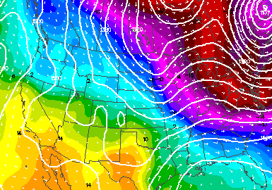
The first image below shows the temperature gradient over the United States. The temperature increases when moving from Northeast
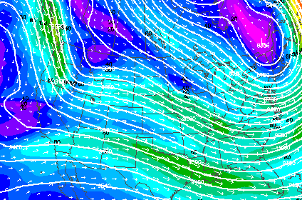
toward Southwest across the country. The temperature gradient is spread out over a large area. The second image shows the polar
jet stream. Notice that instead of one well defined jet stream there are three discernible segments flowing from northwest toward
southeast across the country. The temperature gradient being spread over a large region has also caused the upper level winds to
spread out over a large region.
|
|
|