
METEOROLOGIST JEFF HABY
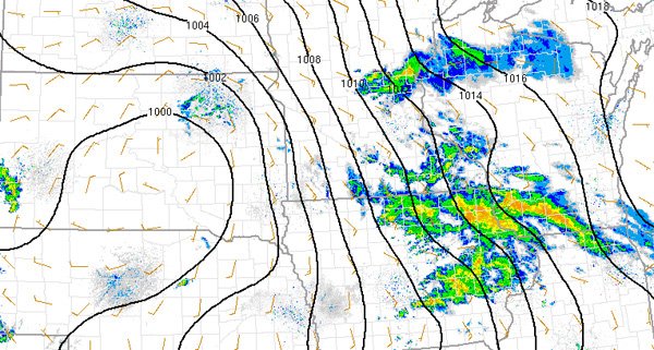
A low pressure system is a region of relatively lower sea level adjusted pressure that occurs over a broad area. The example below
shows a low developing over Nebraska and North Dakota and it also influence neighboring states. The classic counterclockwise flow
around the low pressure can be seen by examining the wind plots in Nebraska and North Dakota. A feature that will be
pointed out on this image are the relatively strong winds.
The stronger winds from the south in the plains and midwest can result in a quick transport of heat and moisture, which is on the side of the
low pressure system that is able to transport air in from a warm and moist source region such as the Gulf of Mexico. Some reasons
the winds can be strong in the plains and midwest are due to the east-west elevation change, the east-west temperature gradient produced by
differences in air masses and the influence of the low pressure itself. Notice the strong winds over Iowa and Minnesota. This can
be seen by the close isobar spacing and the relatively strong wind speeds on the wind plots in this region. Elevation changes,
air masses changes and the low pressure itself can set up a temperature gradient across the plains and midwest. This in turn leads to a
pressure gradient. A stronger pressure gradient will result in stronger winds as is seen by the close spacing of the isobars. The
lifting in the vicinity of the low can also produce a temperature difference since rising air cools. This can also contribute
to stronger winds around the region of lower pressure.
|
|
|