
Just like with any mass, air exerts a force. Like being on the bottom of the ocean of water, we live at the bottom of a sea of air. It is at the bottom where the pressure is highest since all the air above us is pushing down. Thus, when going up in altitude, the pressure will decrease. The image below shows an example of sea level adjusted air pressure. The air pressure is adjusted to sea level so that different regions can be compared without the influence of elevation on the air pressure. This example is from a nice weather day where the air pressure changes little over distance. This results in light winds. The air pressure is the value shown in black to the upper right of several of the station plots. The average sea level air pressure is 1013.25 millibars. Notice many of the values in the example image are near this value. Many of the values are between 1014 and 1019 millibars, indicating a general region of high pressure. Air pressure indicates how much of an influence there is from either high pressure or low pressure. Lower pressure will have values less than 1013 mb and significant low pressure will be much lower than this, for example 990 mb. Values around 1013 mb and higher indicate an influence from a high pressure system. Strong highs will have values well above 1013 mb such as 1030 millibars. Low pressure tends to bring in cloudier, windier and stormy weather while high pressure tends to bring in less clouds, lighter wind and fair weather. 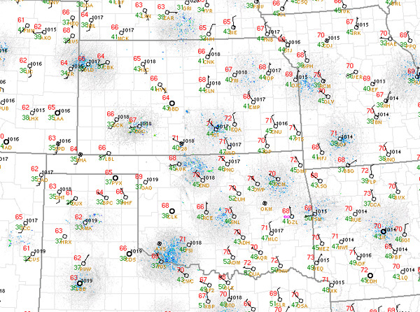 |