
Some say it takes knowledge, nerve, patience and luck to forecast for the eastern Tennessee Valley. They’re right! This part of the southeastern United States contains a number of forecasting pitfalls, including great elevation changes and a latitude that allows for frequent air mass transitions. In truth, there is no way to issue a single, accurate forecast to cover the distinct differences in elevation for East Tennessee for a single time period. Temperature, sky cover, moisture content, winds and precipitation type can (and often do) vary from the three very different elevations. Three individual forecasts are required to cover the 13,200 square mile forecast area. The first topographical area to consider is the Cumberland Plateau. The Plateau is the high ground leading from Middle Tennessee eastward to the Tennessee River Valley. Elevations rise from 385 feet (1) above sea level at Nashville’s highest point, to 2,735 feet at Mt. Roosevelt on the eastern edge of the plateau. From the plateau edge into the valley, a horizontal distance less than a mile, the elevation drops abruptly to 977 feet at Rockwood, TN. That’s 1758 feet in a very short distance! Approximately 80 miles from the eastern rim of the plateau, the Great Smoky Mountains loom as a significant part of the Appalachian Mountain chain, which provide the highest elevations east of the Mississippi River. Mt Mitchell, NC, near Asheville, is the highest point with a measured elevation of 6,684 feet. Clingmans Dome, TN is just behind Mt. Mitchell with a measured height of 6,643 feet. However, measured from base to its highest peak, Mount Le Conte near Gatlinburg, in the Great Smoky Mountains, is the tallest mountain in the Eastern United States. It measures 5,301 feet and has a top elevation of 6,593 feet. In East Tennessee, the Tennessee River valley is oriented northeastward from northern Alabama to Knoxville, TN, running parallel to the Tennessee-North Carolina border. The confluence of the French Broad River and the Holston River mark the beginning of this gently flowing river at Knoxville. The elevation of the valley falls as you travel downstream (southwest) from Knoxville to Chattanooga. Knoxville has an elevation of 889 feet, with the water level near 813 feet above sea level. Chattanooga’s elevation is near 683 feet above sea level. 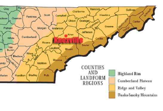 With the various changes in elevation moving from west to east, orographic lifting plays a big role in developing weather in East Tennessee year round. The gradual up-slope along the Cumberland Plateau does little to change the dynamics of a storm system, outside of providing a little more lift. However, the rapid descent of air from the plateau to the valley floor will weaken many storms, reducing the severity of a storm and the amount of precipitation it will produce. And while the Great Smoky Mountains provide the greatest obstacle to advancing air masses in East Tennessee, the result is rarely very severe weather. Sevier County, which makes up much of the Great Smoky Mountains National Park, has not recorded a single tornado since 1950, (when the data base was established). It should also be noted that much of this area is uninhabited due to the national park and the extreme terrain and therefore reports of a tornado or tornado damage would be limited, if one did occur here. If you return due west of Sevier County, across the valley, back to the high ground of the Cumberland Plateau, Cumberland County has recorded 15 tornadoes in the same time period. The most recent, an EF-1, occurred just last week on April 3, 2007. The majority of these tornadoes have been classified as F-2 or F-1, with three F-3 twisters confirmed by the National Weather Service. Severe weather threats are often predicted for the western counties along the edge of the Tennessee Valley. Typically, those storms remain strong for the first 10-15 miles after dropping into the valley from the plateau. After the initial movement over the lower terrain, many of these storms weaken to rain makers and loose their severe characteristics. However, as they move across the valley floor, some storms can regenerate to severe levels. This presents a real forecast problem for the Knoxville area. How do you predict the intensity of these storms? Will they remain in their weakened state or regain the vigor of the elevated storm? To answer these questions, forecasters must rely heavily on observations, storm observers and doppler radar. Forecast models also play a big role in determining if enough dynamic lift is available to continue a storms development at the lower elevation. The same cannot be said for storms that advance from the southwest along the river valley from Huntsville, AL or Chattanooga to the Knoxville area. These storms have no barriers to impede their march and will typically maintain their strength or even intensify. This is especially true during winter weather events. If cold air is in place and a storm develops along the Gulf coast, Knoxvillians stock up on milk and bread because a winter snowstorm will have a great chance to overtake the Knoxville area. The Blizzard of (March) ’93 was one such storm, although it was a monster storm as it moved through Alabama as well. A westward moving winter weather system may leave accumulating snow on the plateau, but provide only a cold rain or just clouds in the valley. Upslope flow will often bring additional snowfall to the Smoky Mountains that the rest of the area simply won’t experience. Rainfall in the valley, where temperatures are milder, will translate to heavy snow in the colder, higher elevations as a winter weather system moves eastward and is forced to rise. In many cases, the mountain tops will take on the white appearance of snow on their westward facing slopes, while the eastern sides are completely void of accumulating snow. In the warmer months this same phenomenon can result in flash flooding. As the air is lifted into the mountains, precipitable moisture is forced out on the western slopes and into the many creeks and streams that rush rapidly down the mountains to the valley below. The sudden onslaught of water can produce a flash flooding environment in a matter of minutes. Great care must be given to a forecast that contains an abundance of moisture moving toward the Smoky Mountains. Research continues to yield new ideas and forecasting techniques to aid meteorologists as they tackle this complex terrain. Often, a close examination of the 1000 mb chart will expose areas of orographic lifting, but that may not be enough unless a deeper understanding of the relationship of topography and atmospheric circulation patterns is known. Likewise, an extended comprehension of the relationship of geographical features to precipitation types and totals would undoubtedly help develop more comprehensive dynamic models for forecasting. Some regressive models have been developed over the years. Donley and Mitchell (1939), discovered a linear relationship between precipitation and elevation in the Southern Appalachians. More recently, Konrad (1995, 1996) found large differences in precipitation types and precipitation totals in the Southern Appalachians, depending on low-level wind direction. Additional studies, additional observation sites and faster computing capabilities will improve forecasts for this diverse terrain. But until that day arrives, knowledge of the forecast area, confidence to follow the data, patience to piece it all together and some good luck will remain the formula to forecast weather for the Eastern Tennessee Valley. References (1) Elevation Data from USGS topographical maps and Topozone.com (2) East Tennessee Map courtesy University of Tennessee-Knoxville Donley, David E., and Richard L. Mitchell. 1939. The relation of rainfall to elevation in the Southern Appalachian region. Transactions-American Geophysical Union 20: 711-721. Konrad, Charles E. 1996. Relationships between precipitation event types and topography in the southern Blue Ridge Mountains of the Southeastern USA. International Journal of Climatology 16: 49-62. Konrad, Charles E. 1995 Maximum precipitation rates in the southern Blue Ridge Mountains of the southeastern United States. Climate Research 5: 159-166. |