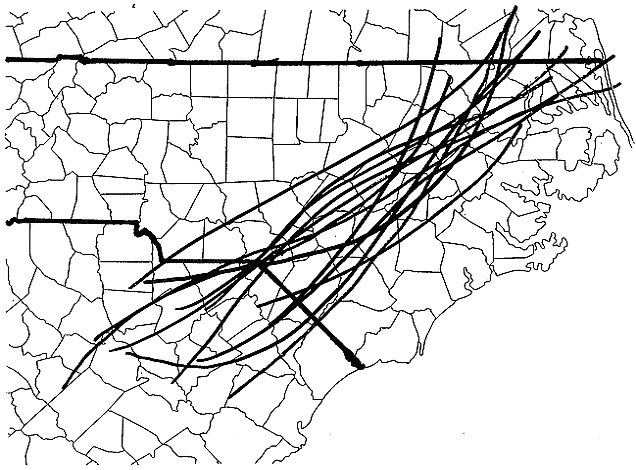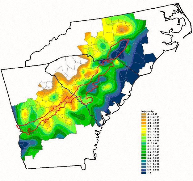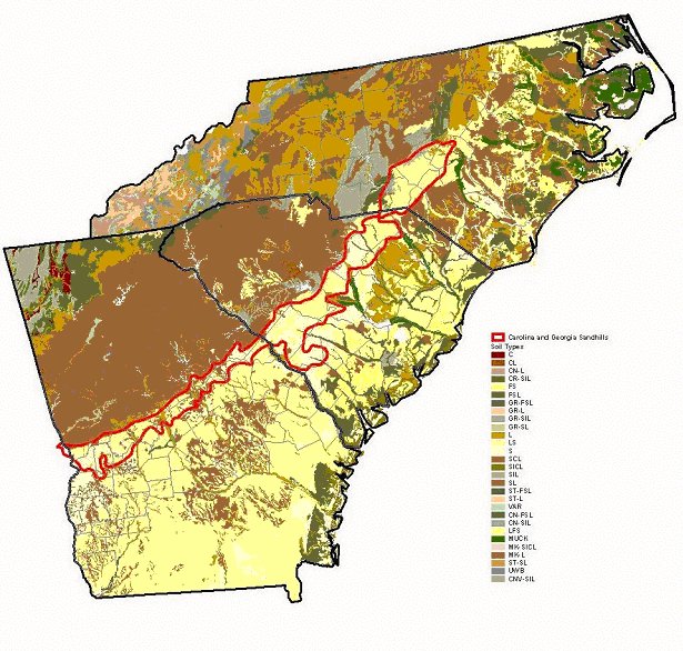
The piedmont trough is a relatively new discovery in the eastern part of North Carolina. The key effects of a piedmont trough are soil type and diurnal heating. The North Carolina Sandhills region of the Southeast is an elongated area of sandy soil that is located adjacent to regions of varying soil type. The Piedmont area in the eastern part of the state has soils that are mainly loam and clay-loam, while a variety of soil types exists in the Coastal Plain to the southeast. It is the differences in these soil types that create differential heating of the surface. Areas with sandy soil will more easily release their moisture to the area, allowing for a higher sensible heat flux than loam or clay-loam soils. This allows more energy to be used for heating the surface rather than evaporating moisture in the soil. Also, the heat capacity for sand is much less than that of clay or loam, so that given the same amount of energy, sandy soil would increase in temperature more than the loam or clay soils. This hot air rises, while the cooler air over nearby regions doesn't, causing a small area of circulation to develop. If there is a southerly wind carrying moisture from the Gulf of Mexico, as is often the case in the Southeast in summer, rain clouds can form or intensify in this circulation. Having moist, densely vegetated regions on both sides of the Sandhills, together with the presence of the sea breeze which reaches as far inland as the Sandhills in the Carolinas, makes the process all the more potent by creating circulation on both sides. Urbanization also plays a role. As the Sandhills' native vegetation is cleared to make way for new development, its soil can dry out even more quickly, increasing the heat differential between it and the moister soils in adjacent regions. These differential surface heating patterns is what creates the "Piedmont Trough". This trough acts as a focusing mechanism for thunderstorms in the summer. Much like a sea breeze influences the location of summer thunderstorms in Florida, the piedmont trough impacts the weather in North Carolina. The trough can act as a lifting mechanism and can help develop convective thunderstorms. The piedmont trough is often a cause for strengthening storms in the area east of the piedmont. The trough is on a smaller, mesoscale level and is not always detected by weather models that look for large scale features. This being the case, this trough is often overlooked and developing thunderstorms in this area are generally missed. The trough is also responsible for strengthening weaker systems and can also revitalize convective systems that pass through the area. The piedmont trough is a common occurrence in the eastern part of North Carolina during the summer months, mainly from June through August, with the most occurrences happening in July. It is responsible for enhancing severe weather and also generating pop-up thunderstorms. Being that this trough is on a smaller scale it is not easily detected. This creates a problem when forecasting the weather for this region. If this feature is missed the forecast will be significantly affected. This can result in underestimation of severity and also an underestimation in precipitation amounts. With its mild winters and fast-draining soil, the region is home to many golf courses, horse farms, retirement communities and resorts whose activities hinge upon the weather forecast. Until recently this particular forecast problem occurred on a daily basis during the summer months. With the discovery of this occurrence there are methods being developed to try better forecast for this weather event. The solution to this problem is to utilize many forecasting tools together to identify the location and intensity of this trough. When combining the WSR-88D radar, the GOES satellite, and surface data, the trough was located 95% of the time. The role that each played is described below: 1) The WSR-88D radar is capable of detecting boundaries even in clear air to a limited range; however, displays from several regional radar sites are necessary to define convergence boundaries in the PBL beyond approximately 50 n mi from the local radar. 2) The GOES satellite is useful for the detection of boundaries well beyond the range of the radar, but an unobscured cloud line must be present in order for it to be of use; in addition, linear cloud features are not always associated with low-level boundaries (over detection problem). 3) Conventional surface data is a relatively weak boundary detection component (under detection problem), yet it usually allowed the nature of the features observed by radar and satellite to be clearly identified; surface data can be used in many instances to detect subtle temperature, moisture, and/or stability discontinuities that define weak, shallow fronts. In conclusion, with the discovery of the Piedmont trough this forecasting problem can now be assessed. With the combination of several forecasting tools this feature can be identified, located, and properly assessed to give a forecaster a more in depth understanding of what processes in the piedmont region that is driving the summertime severe weather.  Location and orientation of Piedmont troughs  July Averaged Monthly Precipitation around the Sandhills Region over the 40 years (1960-1999). The Sandhills are outlined in red.  Soil surface texture in the Carolinas and Georgia References: State Climate Office of North Carolina http://www.nc-climate.ncsu.edu/climate/sandhills.html Businger, S., W. H. Bauman III, and G. F. Watson, 1991: The development of the Piedmont front and associated severe weather on 13 March 1986. Mon. Wea. Rev., 119, 2224-2251 Steven E. Koch and Charles A. Ray: Mesoanalysis of Summertime Convergence Zones in Central and Eastern North Carolina Weather and Forecasting Volume 12, Issue 1 (March 1997) pp. 56-77 |