
Residents in the Piedmont of North Carolina donÆt experience a great deal of wintry weather. Typically, the moisture associated with winter systems that move in from west to east is rung out over the Appalachians, leading to smaller precipitation totals in the Piedmont. There is one scenario that can usher in snow, sleet, and freezing rain into the greater Charlotte area, a Cold Air Damning event. When these events hit the region, forecasting them is difficult as the precipitation type can vary considerably and ice storms are possible. YouÆll often hear your local television or radio meteorologist refer to this as ōa wintry mix.ö Cold Air Damming occurs when a low-level cold air mass becomes trapped because of topography, typically on the east side of a mountain range. The trapped cold air affects the overall weather pattern of the area producing widespread cloud cover, colder temperatures, and various types of freezing precipitation. In the Piedmont of North Carolina this happens when a ridge of strong surface high pressure in the Northeast sends cold air southward (cold air advection) down the east coast. As the air is forced upward by the higher terrain, adiabatic cooling takes place. Bell and Bosart found that up to 30% of cooling occurs through this process. If precipitation is underway, the latent heat loss caused by evaporation of rain or snow or the melting of frozen precipitation leads to diabatic cooling. This process is believed to cause nearly the same percentage as adiabatic cooling according to Bell and Bosart. Each cold air damming event is different, some are cold air advection dominant while others are controlled more by diabatic cooling. In order for cold air damming to occur, a low level anticyclone is required to force upslope flow. Also needed is terrain blocking for adiabatic cooling and an inversion along the top of a cold air pool. Terrain blocking enhances cold air advection because the flow becomes more vertical as winds turn across isobars toward low pressure situated to the west. It may also lead to a greater inversion and the formation of a barrier jet, which is a jet on the windward side of the mountain. The barrier jet may also lead to an increase in surface wind speeds. Cold air damming is a year round occurrence in the Appalachian Mountains. A maximum number of these events take place in the winter months, while few events take place in the summer. Over the last fifty years, the peak of these events has been in December and March. The winter events also last longer than the summer events, often leading to two-day ice storms. 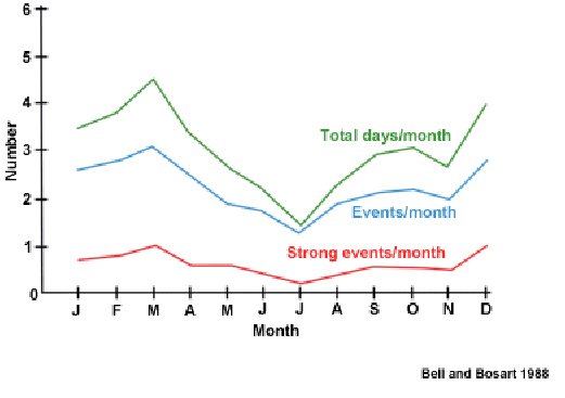 Numerical models are often of little help to meteorologists and forecasters in cold air damming situations because most of the important features are happening in the lowest half-mile of the atmosphere. Model ability to handle the depth and strength of cold air at these levels and at the surface is difficult. Terrain effects are also hard for models to handle. Use of some mesoscale models like COAMPS may be better at forecasting the low-level features. A small change in lapse rate whether at the surface or in the middle levels of the atmosphere make huge differences in precipitation that a forecast area will experience when temperatures are hovering near freezing. Understanding the temperature profiles at various levels will help in determining whether snow, sleet, freezing rain or rain is going to occur. For snow to occur, temperatures below freezing need to occur throughout the atmosphere. Since the snow does not pass through any warm layers on its way down, it reaches the ground as snow. Sleet on the other hand, starts as snow at higher altitudes but falls into a shallow warm layer typically about one mile above the surface where melting takes place. It then falls into another cold layer towards the surface and the water droplets begin to refreeze. Freezing rain is considered the most dangerous form of precipitation in these storms as it can lead to significant icing. Residents of Charlotte and the central Piedmont found this out in December of 2002 when a cold air damming event led to the largest ice storm to ever hit North Carolina. More than three quarters of an inch of ice accumulated on trees and power lines. Over 1.2 million Duke Energy customers were left without power, many for more than two weeks. 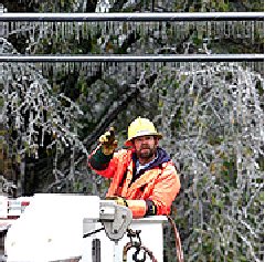 AP Photo Freezing rain begins as falling snow. The snow falls into a warm layer deep enough that total melting occurs and the snow becomes rain. Now falling as rain the precipitation passes through a thin cold layer, above the surface and cools below freezing. Supercooling takes place and the drops themselves donÆt freeze until they hit the frozen ground, power lines, or tree limbs and branches. 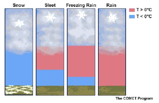 WCCB-TV Charlotte Chief Meteorologist Reg Taylor has forecasted cold air damming events in the Carolinas for more than ten years. ōItÆs a forecasterÆs worst nightmare. You really have to fly by the seat of your pants because the models are very little help.ö Taylor says experience is the key to accurately predicting these types of winter events. ōYears of experience with this kind of weather, seeing it and knowing what to expect is the best teacher. ItÆs really impossible to say when forecasting, in Charlotte it will be freezing rain, in Gastonia youÆll have sleet, and in Rock Hill youÆll have cold rain. There are two many variables even twelve hours before the precipitation begins.ö Taylor says when the event is taking place in real-time itÆs important for the forecaster to explain why this is such a difficult forecast and the small differences that lead to the varying precipitation types. Forecasting and end to cold air damming events is often just as difficult as forecasting the event when it began. There are several things to look for as a damming event weakens. Warm air advection at the surface, including a shift to a southerly wind flow will weaken a damming situation. Surface pressures falling in the cold air or a decrease in cold air depth are also signs that the end of the event is near. In order to give the best forecast possible in a cold air damming situation, model biases should be learned an incorporated during the forecast process. Shallow cold air is not handled well by numerical models, often leading to a forecast that does not support a large draw of cold air when in fact there is sufficient cold air advection taking place. Most importantly, learn from past events and journal information you learn or patterns you see in previous cold air damming events. References ōCold Air Damming: Uses, Example, and Forecast Parameters.ö University Center for Atmospheric Research. http://www.meted.ucar.edu/mesoprim/cad/webcast/print.htm ōAppalachian Cold-air Damming.ö Bell, G.D., and Bosart, L.F. 1988 Mon. Wea. Rev., 116, 137-161. ōCold Air Damming Forecast Tipsö NWS Raleigh, NC & North Carolina State University http://www.ncsu.edu/eos/service/pams/.../CSTARworkshop/20031016.gh.end.tips.ppt ōWorst Ice Storm In Years Devastates The Carolinas.ö Associated Press, 12/16/2002 Haby, Jeff. The Weather Prediction http://www.theweatherprediction.com |