
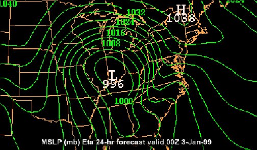
 Introduction There are few things in meteorology that prove more frustrating to a forecaster than the development of cold air damming. This complex phenomenon can ruin an otherwise good forecast. The development of cold air damming not only determines temperature, it can also determine precipitation type and atmospheric stability. The purpose of this paper is to describe the effects of, frequency of, and the atmospheric conditions that lead to cold air damming situations in the Carolina Piedmont. Definition of Cold Air Damming and Conditions that Lead to Its Development According to the American Meteorological Society’s Glossary of Meteorology, cold air damming is defined as “the piling up, or complete blocking, of cold air approaching the slopes of a mountain barrier.” This paper will focus specifically on impacts of cold air damming in the Carolina Piedmont. In simple terms, cold air damming in the focus region develops when high pressure to the north, or northeast, pushes cold, dry air down the eastern side of the Appalachian Mountains. Damming develops as the cold air tries to move up the mountainous terrain. As the air ascends, it cools adiabatically. If the environmental lapse rate is more stable than the dry adiabatic lapse rate, the ascending air becomes cooler than its environment. This causes the upslope flow to slow as it attempts to ascend the terrain. As more and more cold air is pushed southward, the region of damming grows. Since cold air is dense and resists flowing over the mountains, piedmont locations will often be colder than ridge tops in damming scenarios. The Coriolis Force tries to bend the cold air to the right which further locks the air in place against the eastern slopes of the Appalachian Mountains. When the cold air is very deep or has strong forward momentum, the dam can be evident from the Appalachians eastward to the coastal plain, and as far southwest as central and northern Alabama. The Three Types of Cold Air Damming Classic Cold Air Damming  Classic cold air damming is usually initiated by strong high pressure moving eastward toward New England or Eastern Canada following a cold air outbreak. The cold air flows out over the eastern United States as the parent high becomes established over eastern Canada or New England. Ridging will appear on the MSLP chart east of the Appalachians as cold air becomes entrenched and surface pressures rise. In most cases, an area of low pressure exists west of the mountains and weakens as cyclogenesis occurs over the Gulf or Atlantic coastal areas. This first area of low pressure acts to enhance the pressure gradient, which strengthens the dam. The coastal cyclogenesis initiates onshore flow, overrunning of moist air, and increased precipitation. The classic cold air dam is usually the most difficult to scour. Hybrid Cold Air Damming  Hybrid cold air damming originates where cooling due to melting and or evaporation and synoptic scale cold air advection from a parent high-pressure system play nearly equal roles. In most hybrid situations, the parent high maybe progressive, or it could be weak, but in good position. Precipitation develops due to some sort of synoptic-scale forcing or the dam itself. The precipitation over the weak area of cold air advection further cools the air and strengthens the inversion. In-situ Cold Air Damming  In the case of in-situ cold air damming, there is little or no cold air advection initially; in fact solely diabatic processes produce the dam. The surface high-pressure system is usually in an unfavorable location, thus precipitation instigates the development of a cold air dam. This type of event is usually the shortest lived of any cold air damming scenario. The Frequency of Cold Air Damming According to the University Center for Atmospheric Research, or UCAR, cold air damming in the Appalachian Mountains and adjacent piedmont has a summer minimum and a winter maximum. Using a 50 year climatology study provided by UCAR, on average there are two to three cold air damming events per month from October to March, as compared to one to two events per month for the rest of the year. There is also an increase in length per event during the colder months. For example in March or December, events average about one and a half days per event, compared to one day or less per event in July. Forecasting Cold Air Damming Scenarios: Consequences, Challenges, and Solutions Cold air damming presents a complex forecasting situation each time it impacts the Carolina piedmont. In winter months, damming development can lead to significant winter weather events. In fact, most winter storms that develop in the Carolina Piedmont are a result of either classic or hybrid cold air damming. During warmer months, damming events can lead to major temperature and precipitation forecast busts. When forecasting during cold air damming events, the meteorologist must understand the processes that come together to produce precipitation. The processes that maintain or scour the cold air dam should also be explored. As warm, moist air is lifted above the dome of cold air at the surface, widespread cloud cover and precipitation often develops. The cloud cover and precipitation act to reinforce the cold air due to evaporative cooling and the blocking of incoming solar radiation. In a classic cold air damming scenario, heavy precipitation can develop in response to coastal cyclogenesis. The coastal cyclogenesis causes copious moisture transport from the south or southeast to be lifted up an over the trapped cold air. This isentropic lifting can act to increase precipitation rates just east of the mountains. If the air is cold enough, a significant winter storm can develop. The depth of the cold air will determine the precipitation type. Unfortunately, this type of situation often produces damaging ice storms in the Carolina Piedmont. 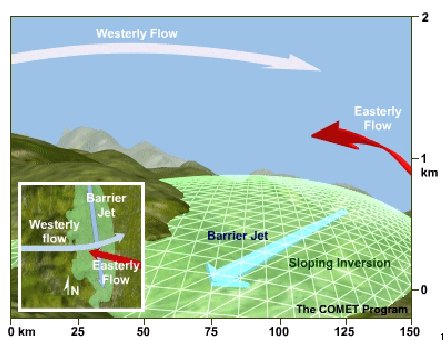 In well-developed, long-lived cases, a barrier jet can develop just east of the slopes of the Appalachians. The barrier jet is defined as a mountain-parallel region of significant low-level winds that develops when significant blocking occurs simultaneously with the development of a low-pressure system to the south. The barrier jet acts to reinforce the cold air at the surface as moisture continues to stream in from the south or southeast. Hybrid cold air damming events can also lead to the development of winter weather over the Carolina piedmont if temperatures are cold enough. In-situ cold air damming events can have periods of short-lived winter weather. However, because there is no direct connection to a source region of cold air, in-situ damming often scours more rapidly. If temperatures are not in the critical range for winter weather, cold air damming events can still wreak havoc on a forecast. Temperatures will show little or no diurnal trend and precipitation can be much more widespread than forecast by computer models. Fog also tends to be a significant impact, especially as the dam begins to scour. When developing a forecast for a potential cold air damming event, mesoscale models such as the newly improved WRF-NAM tend to perform better due to their better horizontal and vertical resolutions. It is also important to study how the forecast area has been impacted by cold air damming events in the past and notice factors that contribute to increased precipitation rates, temperature rises and falls, as well as what causes the dam to eventually scour. Conclusion In order to more accurately forecast the development and evolution of cold air damming events, an emphasis on improving mesoscale models is important. These models have been greatly improved over the past few years, which has allowed the forecasting of damming events to improve. However, forecasters still have problems with predicting the spatial distribution of the cold air, the vertical temperature profile during damming events, and the duration of these events. It is our duty to continue to learn more about cold air damming, with particular interest on the development of winter storms in the Carolina Piedmont to better prepare the public for hazardous weather. References Haby, Jeff. The Weather Prediction. http://www.theweatherprediction.com “Cold Air Damming: Uses, Example, and Forecast Parameters.” University Center for Atmospheric Research. http://www.meted.ucar.edu/mesoprim/cad/webcast/print.htm Glossary of Meteorology: Second Edition. American Meteorological Society. 2000. |