
The term derecho, coined by Dr. Gustavus Hinrichs in 1888, describes a wind event that does not fit the definition of a tornado. Derechos are strong straight line wind storms that cover an extensive area. To be identified as a derecho, the coverage area of the must be at least 240 miles in length with wind gust speeds exceeding 57 miles per hour. Severe wind reports must progress chronologically and there must be 3 reports, separated by 40 miles or more, of F1 damage and/or gusts greater than 74 miles per hour. Also, no more than 3 hours can elapse between successive severe wind damage reports. Derechos are associated with bands of rapidly moving thunderstorms, typically taking on the shape of a bow echo. Bow echoes form when an area of mid-level steering flow (10,000 to 20,000 feet / greater than 40 knots) is stronger than the surrounding flow, causing the squall line or multicell storms to surge in the middle. This causes a cyclonic rotation on the northern portion and an anticyclonic rotation on the southern portion of the cloud formation. See Figure 1. Strong mid-level flow not only causes the formation to surge, but to tilt forward. 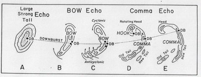 This allows the downdraft to remain separate from the updraft. As moisture precipitates out and encounters a dry layer of air, evaporational cooling occurs. The drier the air, the more intense the evaporational cooling, the more intense the negative buoyancy the air will obtain, the harder the air will hit the ground and the faster it will spread out. Also, due to the tilt of the storm, the downdraft will hit the surface at an angle matching the direction of the storm. This means stronger wind speeds will push out and ahead of the actual storm itself. Wind speeds will not remain constant along the path of a derecho. In fact, there may be areas where recorded wind speeds are lower than the stated severe weather criteria of 57 miles per hour. Other areas will record wind speeds well in excess of the stated criteria, sometimes exceeding 100 miles per hour. These patches of non-severe winds embedded within severe winds point to the fact that a derecho is not a single wind event, but rather a series of wind events called downbursts. Downbursts are further classified into macrobursts (>2.5 miles in diameter) and microbursts (<2.5 miles in diameter). When a covey of downbursts occurs along a path 240 miles in length, then a derecho has occurred. See Figure 2. 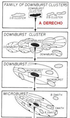 There are three different types of derechos. The first type is called the serial derecho. This type of derecho is associated with strong, migrating low pressure systems in the mid-latitudes. Since these storms are large and generally impact an area many hundreds of miles long, the chance of squall lines and multicell thunderstorms developing into numerous bow echoes exists, further heightening the chance of the development of a derecho. The second type is called a progressive derecho. This type of derecho is associated with a relatively short line of thunderstorms that will take the shape of a bow echo. The width of this derecho can vary, staying with a narrow width across its traveled distance to starting with a narrow width, but gradually expanding that width as it advances. It may start out as a single bow echo, but it can develop into a full-blown squall line. The third type of derecho is called a hybrid. This type of derecho contains traits of the first two derechos. For example, a derecho which is associated with a strong migrating low pressure center but whose path starts narrow and gradually expands with progression is typically called a hybrid derecho. The chances of a derecho occurring in Mississippi are significantly lower than that of the Midwest. The best chances for the occurrence of derechos in Mississippi are from September through April, when the battle between continental polar air and maritime tropical area moves further south with the jet stream. During this time frame, derechos can be experienced from east Texas through the Gulf Coast states. Two other major axes of occurrence exist to the north during the warm season, when the maritime tropical air mass can penetrate further inland. From May through August, derechos will occur on an axis extending from the Upper Mississippi River Valley to the Ohio River Valley, with a second axis of occurrence existing from the mid-Mississippi River Valley into the Southern Plains. Forecasting derechos is extremely difficult. While we can get an idea synoptically where to expect severe weather outbreaks, translating this into the mesoscale is the problem. When thunderstorms do start developing, it is impossible to say which cells will become severe and which ones will not. This is due to the little differences in temperature and moisture where the particular cell is developing. These idiosyncrasies can make the difference between a colder cell core with fairly warm temperatures outside of the cell producing enough of a thermal gradient to increase the mid-level steering flow which initiates a bow echo. Downbursts can be very localized. Microbursts tend to be less than 2.5 miles in diameter. Macrobursts, although larger, will soon lose their steam before reaching derecho criteria on their own. Trying to forecast these conditions over a 240 mile span is a tremendous task. The advent and gradual development of Doppler radar has increased our ability to identify threatening weather signatures and nowcast the possibility of derechos. The ability of Doppler to peer into a storm and root out some of its secrets can help us to localize warnings to those areas we see bow echoes developing in. If there has been a previous history with the approaching convection of downbursts meeting NWS severe wind gust criteria, then those trends can be utilized to provide advance warning to people in the path of these storms. As good as satellite imagery and Doppler radar are, old fashioned weather observing may be the best means of nowcasting for the immediate area and forecasting for those areas to later be impacted by the approaching storm, especially in the near future. Our current inability to forecast this mesoscale phenomenon can have dire consequences for the individuals who encounter it unprepared. Due to the nature of a downburst, campers and boaters may be able to see the weather getting bad, but have no idea of fast it is going to strike and in some cases, will be unable to return to a place of safety and be left to the mercy of the elements. Boats can be overturned and campers can be crushed by falling trees. In residential areas, mobile homes, with their large sail areas, can be overturned easily. Houses surrounded by trees also face the danger of being damaged or crushed by falling trees. In metropolitan areas, large power outages can occur, producing food, water, and ice shortages impacting thousands of people. The 16 February 2001 derecho which moved through central Mississippi and Alabama provided extensive damage. Wind gusts were recorded over 110 miles per hour, 6,100 homes were damaged or destroyed, and 400,000 homes were left without power in Alabama. The Mid South Derecho of 22 July 2003 significantly impacted the Memphis metropolitan area and northern Mississippi, leaving 750,000 people without power for almost a week. Damaged homes and lack of electricity severely hindered people from conducting their day to day lives. In order for forecasting shortfalls to be resolved when it comes to predicting mesoscale events such as derechos, more data needs to be collected. Unfortunately, that takes time. However, research is being conducted at the National Severe Storms Laboratory in Norman, Oklahoma. Much of their research has been recorded in American Meteorological Society (AMS) papers detailing the steps and theories to their research. Research such as that found in Simulation of a Progressive Derecho Using Composite Initial Conditions by Michael Coniglio and David Stensrud will ultimately lead to better forecasting of these events to provide advance warning. These gentlemen took a composite of the data to several previous derecho events and loaded them into the MM5 model. This research delved into a convective environment and what needed to happen to produce a derecho. The ability to manipulate the model data allowed them play with environmental conditions enough to see how those changes impacted the development of derechos. In conclusion, much research has yet to be completed in order to for us to accurately forecast the occurrence of a derecho. Our ability to look at a synoptic situation and warn the general population of impending severe weather is good, but translating that into a mesoscale forecast is the challenge we face. Higher resolution models that are provided consistent data over derecho prone areas is one of the keys to success. But in the meantime, utilization of Doppler radar and our observation networks will have to serve us in identifying this deadly weather event and for warning the American public. Acknowledgements Ashley, W. S., and T. L. Mote, 2004: Hazards of long-lived convectively generated high winds in the United States. Preprints, 22nd Conf. on Severe Local Storms, Hyannis, MA, Amer. Meteor. Soc, Paper 7A.2, 5 pp Congilio, M. C., and D. J. Stensrud, 2001: Simulation of a progressive derecho using composite initial conditions. Mon. Wea. Rev. Coniglio, M. C., D. J. Stensrud, and M. B. Richman, 2004: An observational study of derecho-producing convective systems. Wea. Forecasting. Coniglio, M. C., and D. J. Stensrud, 2004: Interpreting the climatology of derechos. Wea. Forecasting. Evans, J. S., and C. A. Doswell III, 2001: Examination of derecho environments using proximity soundings. Wea. Forecasting. Fujita, T. T., and R. W. Wakimoto, 1981: Five scales of airflow associated with a series of downbursts on 16 July 1980. Mon. Wea. Rev., 109, 1438-1456. Hinrichs, G., 1888: Tornadoes and derechos. Amer. Meteor. J. Johns, R. H. and J. S. Evans, 2004: About Derechos. NOAA Storm Prediction Center. 27-30 March 2007. http://www.spc.noaa.gov/misc/AbtDerechos/derechofacts.htm#help |