
Cold Air Damming is synoptic phenomena which can be present throughout the world; anywhere a mountain range is present. This weather pattern occurs when low level cold air is blocked by topography. Cold air damming occurs within the United States in two places, East of the Rockies, and East of the Appalachian Mountains. In this paper I will focus on the cold air damming which takes place east of the Appalachians, and how it affects the nature of precipitation through a real-life forecasting example. Cold air damming can occur anytime throughout the year, but the majority of the time is occurs is during the winter. According to Bell and Bosart, the average cold air damming scenario will last approximately four days during the winter. In the graphic below you can see there is a sharp peak of cold air damming events which occur in December and March. 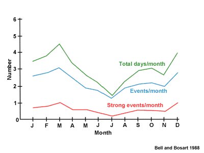 There are three types of cold air damming that occur. The first of the types is classic cold air damming; this type will be discussed later. The second type is in-situ cold air damming, this is where little or no cold air advection takes place, but diabatic cooling generates the cold air which is dammed east of the Appalachians. The third type is hybrid cold air damming. Hybrid cold air damming is a combination of both classic and in-situ cold air damming. In this paper I will focus on the classic cold air damming scenario. There are three main contributing factors which lead to cold air damming. The first of which is cold air advection. This is generally induced by a high pressure system which is located to the north of the affected region. As the surface winds flow from the north and northeast the winds become trapped east of the Appalachians. The second factor is adiabatic cooling. As the surface wind flow comes in contact with the mountains is the air is forced up causing the air to cool further due to adiabatic cooling, 30% of cooling occurs due to adiabatic cooling. The third influence on the cold air is diabatic cooling. This is caused by latent heat loss due to melting or evaporation of any precipitation which is falling into the underlying cold dry air. The classic cold air damming scenario is the easiest form of cold air damming to spot and forecast, but be aware it does have its challenges. Classic cold air damming is setup when a surface high is situated in the Northeast United States; this usually follows the passing of a strong east coast cyclone. As the cold air is forced south and southwest from the high the air is trapped in the low levels by the mountain, this is the beginning of a classic cold air damming situation. This situation is easily seen on the surface charts by the dipping of the isobars between the Appalachians and the East Coast. As the air hits the mountains it is force to rise and cool, therefore reinforcing the cold air in place. If a low pressure system is to the south, overrunning may occur which could lead to a strong stratiform deck and possible precipitation. This is where the challenge of forecasting cold air damming comes in. The graphic below is an example of a classic forecasting problem which faces forecasters in the Northeast every winter. 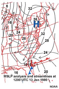 In this classic example of cold air damming, the underlying cold air is well entrenched east off the Appalachian Mountains and there is a weak-moderate low situated over the Southeast United States. As this situation sets up overrunning from the low forms a stratiform cloud deck north, into the mid Atlantic region. As the precipitation begins to fall the freezing level is at 2000 feet. Many forecasters in the Northeast have seen this situation before. The models predict the onset of the cold air damming event but the precipitation forecasts from around the area tend to favor rain with a change to snow throughout the area. Here is where your experience comes in to play, do you forecast by what the models say, or do you use your experience and understanding of the area with the model data as a guide to tailor your forecast?. The models predict that the cold flow from the north would continue for the next few days, but you are seeing the models lag behind in the forecasted strength of the high. Also the low to the south intensified faster than the models have predicted. This sets up a situation where if everything would have stayed true to the initial model rain would fall into a dry atmosphere, and through diabatic cooling, the freezing level would have descended to the surface and snow would have occurred, but this is not the case. As the rain would start to fall, the evaporational cooling near the surface would drop temperatures below the freezing point, but at 3000 feet warm air would intruded from the south. This would be a dangerous setting for a large scale freezing rain event. Instead of the snow blanketing the area overnight the Mid-Atlantic region would wake up to a layer of ice. Power and telephone lines would be down, there would be numerous vehicle accidents, and flights at the airport would be cancelled and delayed. This situation is similar to what occurred on 13-14 February 2007 in the Baltimore area. For this storm most forecasters were playing catch up as the storm progressed instead of being aware of the situation and seen the signs that the pattern was changing. Had the forecasters been on top of the pattern change they would have been able to inform the public in a timely manner and possibly lessen the blow this storm had on the region. This was a very hard storm to forecast, but we can learn from this situation. Stay ahead of your forecast. Don’t be afraid to amend your forecast when the situation change, learn and live by model biases. Models are a wonderful invention but they do have their problems. To make a good forecaster you need to be aware of past weather events and how the synoptic situation played out in your area. At least once every year cold air damming in the Northeast tends to blow a forecast. Hopefully by learning from past mistakes and keeping ahead of the situation, you won’t be in this situation with a busted forecast. References: Bell, G.D., and L. Bosart, 1988: Appalachian cold-air damming. Mon. Wea. Rev., 116, 137-161. Hartfield, G., 1999: Cold air damming/coastal fronts. CSTAR Project, 2000: Improving Forecasts of Topographically-Forced Weather Systems in the Carolinas and Virginia. Cooperative effort involving North Carolina State Univ., and WFOs at Raleigh and Morehead City, NC, Wakefield, VA, and Greer, SC. COMET/ University Corporation for Atmospheric, 2001: Cold Air Damming. |